
Spenden
Rüste dich für dein nächstes Abenteuer:
Als Amazon-Partner verdient diese Seite an qualifizierten Käufen, ohne dass Ihnen zusätzliche Kosten entstehen.
Topografische Karte Queen Valley
Klicken Sie auf die Karte, um die Höhe anzuzeigen.
Spenden
Rüste dich für dein nächstes Abenteuer:
Als Amazon-Partner verdient diese Seite an qualifizierten Käufen, ohne dass Ihnen zusätzliche Kosten entstehen.
Queen Valley
Queen Valley is located at 33°17′42″N 111°17′52″W / 33.29500°N 111.29778°W / 33.29500; -111.29778, at an elevation of 2000 feet along the south side of the west flowing Queen Creek. The Tonto National Forest boundary and Comet Peak (2681 ft.) lie 1.5 miles to the east. The dam for the Whitlow Ranch Flood Control Basin is one mile to the east.
Spenden
Rüste dich für dein nächstes Abenteuer:
Als Amazon-Partner verdient diese Seite an qualifizierten Käufen, ohne dass Ihnen zusätzliche Kosten entstehen.
Über diese Karte
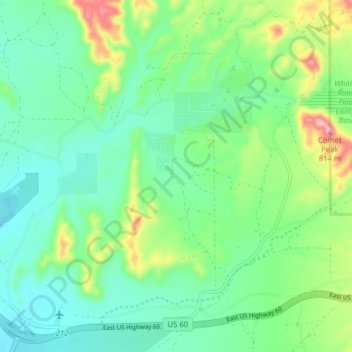
Name: Topografische Karte Queen Valley, Höhe, Relief.
Ort: Queen Valley, Pinal County, Arizona, United States (33.25274 -111.34105 33.31838 -111.26798)
Durchschnittliche Höhe: 633 m
Minimale Höhe: 568 m
Maximale Höhe: 804 m
Spenden
Rüste dich für dein nächstes Abenteuer:
Als Amazon-Partner verdient diese Seite an qualifizierten Käufen, ohne dass Ihnen zusätzliche Kosten entstehen.
Andere topografische Karten
Klicken Sie auf eine Karte, um ihre Topografie, ihre Höhe und ihr Relief anzuzeigen.
Kearny
United States > Arizona > Pinal County
Kearny Airport is a general aviation airport located in the southern section of the town. In 2003 it received the Arizona Department of Transportation's Airport of the Year award. The airport has a single asphalt runway, 3,400 feet (1,000 m) in length and 60 feet (18 m) in width, with a field elevation of…
Durchschnittliche Höhe: 578 m
Oracle
United States > Arizona > Pinal County
Oracle has a cold semi-arid climate at an altitude of 4,500 feet (1,400 m). The record high temperature for Oracle was 109 °F (43 °C) recorded in July 1995. The record low temperature was 6 °F (−14 °C) recorded in December 1990. In January, the average high temperature is 56.7 °F (14 °C) with a low of…
Durchschnittliche Höhe: 1’380 m
Spenden
Rüste dich für dein nächstes Abenteuer:
Als Amazon-Partner verdient diese Seite an qualifizierten Käufen, ohne dass Ihnen zusätzliche Kosten entstehen.
Superior
United States > Arizona > Pinal County
Superior has a hot semi-arid climate. In January, the average high temperature is 61 °F (16 °C) with a low of 43 °F (6 °C). In July, the average high temperature is 98 °F (37 °C) with a low of 76 °F (24 °C). Annual precipitation is just over 18 inches, but is higher at greater altitudes. Despite its…
Durchschnittliche Höhe: 959 m
Spenden
Rüste dich für dein nächstes Abenteuer:
Als Amazon-Partner verdient diese Seite an qualifizierten Käufen, ohne dass Ihnen zusätzliche Kosten entstehen.
Spenden
Rüste dich für dein nächstes Abenteuer:
Als Amazon-Partner verdient diese Seite an qualifizierten Käufen, ohne dass Ihnen zusätzliche Kosten entstehen.
Maricopa
United States > Arizona > Pinal County
The topography in Maricopa is flat, with several mountain ranges 10 to 20 miles away. The elevation of Maricopa is 1190 feet.
Durchschnittliche Höhe: 369 m
Spenden
Rüste dich für dein nächstes Abenteuer:
Als Amazon-Partner verdient diese Seite an qualifizierten Käufen, ohne dass Ihnen zusätzliche Kosten entstehen.
Spenden
Rüste dich für dein nächstes Abenteuer:
Als Amazon-Partner verdient diese Seite an qualifizierten Käufen, ohne dass Ihnen zusätzliche Kosten entstehen.
Maricopa
United States > Arizona > Pinal County
The topography in Maricopa is flat, with several mountain ranges 10 to 20 miles away. The elevation of Maricopa is 1190 feet.
Durchschnittliche Höhe: 369 m
Spenden
Rüste dich für dein nächstes Abenteuer:
Als Amazon-Partner verdient diese Seite an qualifizierten Käufen, ohne dass Ihnen zusätzliche Kosten entstehen.
Superior
United States > Arizona > Pinal County
Superior has a hot semi-arid climate. In January, the average high temperature is 61 °F (16 °C) with a low of 43 °F (6 °C). In July, the average high temperature is 98 °F (37 °C) with a low of 76 °F (24 °C). Annual precipitation is just over 18 inches, but is higher at greater altitudes. Despite its…
Durchschnittliche Höhe: 959 m
Spenden
Rüste dich für dein nächstes Abenteuer:
Als Amazon-Partner verdient diese Seite an qualifizierten Käufen, ohne dass Ihnen zusätzliche Kosten entstehen.
Oracle
United States > Arizona > Pinal County
At an altitude of 4,500 feet (1,400 m), Oracle has a Mediterranean climate (Köppen Csa), somewhat similar to Prescott further northwestward. Unlike most climates of its type, only the early summer is dry, with monsoonal thunderstorms producing substantial rain in July and August. The winter season from…
Durchschnittliche Höhe: 1’380 m
Spenden
Rüste dich für dein nächstes Abenteuer:
Als Amazon-Partner verdient diese Seite an qualifizierten Käufen, ohne dass Ihnen zusätzliche Kosten entstehen.
Heaton
United States > Arizona > Pinal County > Maricopa
Heaton is a populated place situated in Pinal County, Arizona, United States. Originally called Maricopa Station, it served as a stop on the railroad line, where passengers transferred to stagecoach. The post office at this location was simply named Maricopa. During a land boom in the late 1880s, it was…
Durchschnittliche Höhe: 366 m
Spenden
Rüste dich für dein nächstes Abenteuer:
Als Amazon-Partner verdient diese Seite an qualifizierten Käufen, ohne dass Ihnen zusätzliche Kosten entstehen.