
Spenden
Rüste dich für dein nächstes Abenteuer:
Als Amazon-Partner verdient diese Seite an qualifizierten Käufen, ohne dass Ihnen zusätzliche Kosten entstehen.
Topografische Karte Huntington
Klicken Sie auf die Karte, um die Höhe anzuzeigen.
Spenden
Rüste dich für dein nächstes Abenteuer:
Als Amazon-Partner verdient diese Seite an qualifizierten Käufen, ohne dass Ihnen zusätzliche Kosten entstehen.
Huntington
Huntington is located in the southwestern corner of West Virginia, on the border with Ohio, on the southern bank of the Ohio River, at the confluence with the Guyandotte River. The city lies at 38°25′9.30″N 82°26′42.55″W / 38.4192500°N 82.4451528°W / 38.4192500; -82.4451528 (38.4192496, -82.4451540), with an elevation of 564 feet (172 m) above sea level. According to the United States Census Bureau, the city has an area of 18.461 square miles (47.81 km2), of which 16.219 square miles (42.01 km2) is land and 2.242 square miles (5.81 km2) is water. The Guyandotte River joins the Ohio River about 5 miles (8.0 km) east of downtown. Huntington fills the roughly three-mile wide flood plain of the south bank of the Ohio River for eighty square blocks and portions of the hills to the immediate south and southeast.
Spenden
Rüste dich für dein nächstes Abenteuer:
Als Amazon-Partner verdient diese Seite an qualifizierten Käufen, ohne dass Ihnen zusätzliche Kosten entstehen.
Über diese Karte
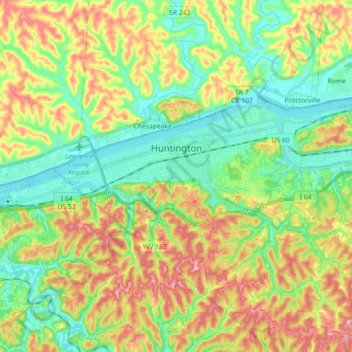
Name: Topografische Karte Huntington, Höhe, Relief.
Ort: Huntington, Cabell County, West Virginia, United States (38.37599 -82.53179 38.43970 -82.35319)
Durchschnittliche Höhe: 218 m
Minimale Höhe: 156 m
Maximale Höhe: 314 m
Spenden
Rüste dich für dein nächstes Abenteuer:
Als Amazon-Partner verdient diese Seite an qualifizierten Käufen, ohne dass Ihnen zusätzliche Kosten entstehen.
Andere topografische Karten
Klicken Sie auf eine Karte, um ihre Topografie, ihre Höhe und ihr Relief anzuzeigen.