
Topografische Karte Arapaho
Klicken Sie auf die Karte, um die Höhe anzuzeigen.
Über diese Karte
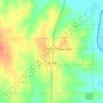
Name: Topografische Karte Arapaho, Höhe, Relief.
Ort: Arapaho, Custer County, Oklahoma, 73620, United States (35.56986 -98.97219 35.58419 -98.94898)
Durchschnittliche Höhe: 494 m
Minimale Höhe: 469 m
Maximale Höhe: 521 m
Andere topografische Karten
Klicken Sie auf eine Karte, um ihre Topografie, ihre Höhe und ihr Relief anzuzeigen.
Weatherford
United States > Oklahoma > Custer County > Weatherford > Weatherford
Weatherford is located at 35°32′18″N 98°41′14″W / 35.53833°N 98.68722°W / 35.53833; -98.68722 (35.5384097, -98.6872467). The elevation is 1,634 feet (498 m). According to the United States Census Bureau, the city has a total area of 7.05 square miles (18.3 km2), all land.
Durchschnittliche Höhe: 517 m