
Spenden
Rüste dich für dein nächstes Abenteuer:
Als Amazon-Partner verdient diese Seite an qualifizierten Käufen, ohne dass Ihnen zusätzliche Kosten entstehen.
Topografische Karte Wisdom
Klicken Sie auf die Karte, um die Höhe anzuzeigen.
Spenden
Rüste dich für dein nächstes Abenteuer:
Als Amazon-Partner verdient diese Seite an qualifizierten Käufen, ohne dass Ihnen zusätzliche Kosten entstehen.
Wisdom
Wisdom is located at 45°36′58″N 113°26′59″W / 45.61611°N 113.44972°W / 45.61611; -113.44972 (45.616120, -113.449742). According to the United States Census Bureau, the CDP has a total area of 0.99 square miles (2.56 km2), of which 0.98 square miles (2.54 km2) is land and 0.0077 square miles (0.02 km2), or 0.82%, is water. Wisdom's average elevation is 6,245 feet (1,903 m), about 1.2 miles above sea level.
Spenden
Rüste dich für dein nächstes Abenteuer:
Als Amazon-Partner verdient diese Seite an qualifizierten Käufen, ohne dass Ihnen zusätzliche Kosten entstehen.
Über diese Karte
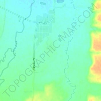
Name: Topografische Karte Wisdom, Höhe, Relief.
Ort: Wisdom, Beaverhead County, Montana, 59761, United States (45.59843 -113.45377 45.62174 -113.43730)
Durchschnittliche Höhe: 1’848 m
Minimale Höhe: 1’838 m
Maximale Höhe: 1’871 m
Spenden
Rüste dich für dein nächstes Abenteuer:
Als Amazon-Partner verdient diese Seite an qualifizierten Käufen, ohne dass Ihnen zusätzliche Kosten entstehen.