
Topografische Karte Crognaleto
Interaktive Karte
Klicken Sie auf die Karte, um die Höhe anzuzeigen.
Über diese Karte
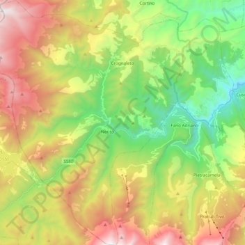
Name: Topografische Karte Crognaleto, Höhe, Relief.
Ort: Crognaleto, Teramo, Abruzzo, 64043, Italy (42.48322 13.38908 42.62395 13.57659)
Durchschnittliche Höhe: 1’213 m
Minimale Höhe: 328 m
Maximale Höhe: 2’444 m
Crognaleto is a comune and city of slightly less than 2,000 people in the Province of Teramo, central Italy. Crognaleto sits at an elevation of 1,105 metres (3,625 ft) and has its communal administrative offices in the frazione (outlying area) of Nerito. The commune of Crognaleto sits on the slopes of the Monti della Laga mountain range and extends across both the northern and the southern slopes of the Vomano Valley. It lies within the Gran Sasso e Monti della Laga National Park.
Andere topografische Karten
Klicken Sie auf eine Karte, um ihre Topografie, ihre Höhe und ihr Relief anzuzeigen.
Martinsicuro
Martinsicuro, Unione dei Comuni della Val Vibrata, Teramo, Abruzzo, 64014, Italy
Durchschnittliche Höhe: 40 m
Montorio al Vomano
Montorio al Vomano, Teramo, Abruzzo, 64046, Italy
Durchschnittliche Höhe: 545 m
Prati di Tivo
Prati di Tivo, Pietracamela, Teramo, Abruzzo, 64047, Italy
Durchschnittliche Höhe: 1’522 m
Civitella del Tronto
Civitella del Tronto, Unione dei Comuni della Val Vibrata, Teramo, Abruzzo, Italy
Durchschnittliche Höhe: 490 m
Villa Piano
Italy > Abruzzo > Teramo > Isola del Gran Sasso d'Italia
Villa Piano, Isola del Gran Sasso d'Italia, Teramo, Abruzzo, 64045, Italy
Durchschnittliche Höhe: 583 m
Pietracamela
Pietracamela, Teramo, Abruzzo, 64047, Italy
Durchschnittliche Höhe: 1’436 m
Isola del Gran Sasso d'Italia
Isola del Gran Sasso d'Italia, Teramo, Abruzzo, 64045, Italy
Durchschnittliche Höhe: 992 m
Castel Castagna
Castel Castagna, Teramo, Abruzzo, Italy
Durchschnittliche Höhe: 376 m
Cellino Attanasio
Cellino Attanasio, Teramo, Abruzzo, Italy
Durchschnittliche Höhe: 288 m
Collalto-Frisoni
Italy > Abruzzo > Teramo > Isola del Gran Sasso d'Italia
Collalto-Frisoni, Isola del Gran Sasso d'Italia, Teramo, Abruzzo, 64042, Italy
Durchschnittliche Höhe: 413 m
Castiglione Messer Raimondo
Castiglione Messer Raimondo, Teramo, Abruzzo, 64034, Italy
Durchschnittliche Höhe: 292 m
Gran Sasso d'Italia
Italy > Abruzzo > Teramo > Isola del Gran Sasso d'Italia
Gran Sasso d'Italia, Isola del Gran Sasso d'Italia, Teramo, Abruzzo, Italy
Durchschnittliche Höhe: 1’976 m
Colonnella
Colonnella, Unione dei Comuni della Val Vibrata, Teramo, Abruzzo, Italy
Durchschnittliche Höhe: 102 m