
Topografische Karte Savoy
Interaktive Karte
Klicken Sie auf die Karte, um die Höhe anzuzeigen.
Über diese Karte
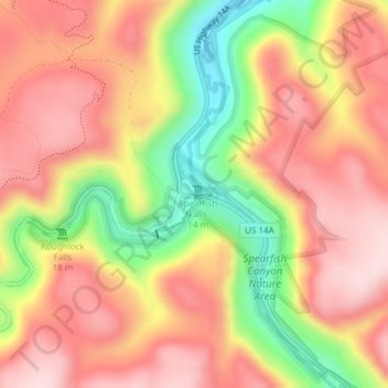
Name: Topografische Karte Savoy, Höhe, Relief.
Ort: Savoy, Lawrence County, South Dakota, United States (44.35035 -103.93248 44.35495 -103.92877)
Durchschnittliche Höhe: 1’665 m
Minimale Höhe: 1’481 m
Maximale Höhe: 1’789 m
Andere topografische Karten
Klicken Sie auf eine Karte, um ihre Topografie, ihre Höhe und ihr Relief anzuzeigen.
Spearfish
United States > South Dakota > Lawrence County
Spearfish, Lawrence County, South Dakota, United States
Durchschnittliche Höhe: 1’171 m
Deadwood
United States > South Dakota > Lawrence County
Deadwood, Lawrence County, South Dakota, 57732, United States
Durchschnittliche Höhe: 1’511 m
Terry Peak
United States > South Dakota > Lawrence County
Terry Peak, Lawrence County, South Dakota, United States
Durchschnittliche Höhe: 1’940 m
Cheyenne Crossing
United States > South Dakota > Lawrence County
Cheyenne Crossing, Lawrence County, South Dakota, United States
Durchschnittliche Höhe: 1’784 m
Bridal Veil Falls
United States > South Dakota > Lawrence County
Bridal Veil Falls, Lawrence County, South Dakota, United States
Durchschnittliche Höhe: 1’502 m
Spearfish
United States > South Dakota > Lawrence County > Spearfish
Spearfish, Lawrence County, South Dakota, 57783, United States
Durchschnittliche Höhe: 1’291 m
Lead
United States > South Dakota > Lawrence County
Lead, Lawrence County, South Dakota, United States
Durchschnittliche Höhe: 1’605 m