
Topografische Karte Marsh Crossing
Interaktive Karte
Klicken Sie auf die Karte, um die Höhe anzuzeigen.
Über diese Karte
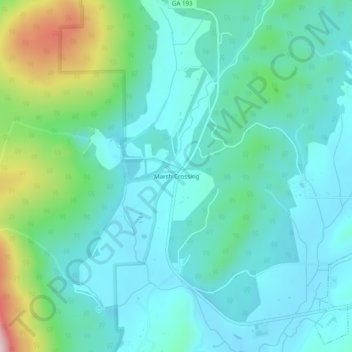
Name: Topografische Karte Marsh Crossing, Höhe, Relief.
Ort: Marsh Crossing, Walker County, Georgia, United States (34.69730 -85.34829 34.73730 -85.30829)
Durchschnittliche Höhe: 312 m
Minimale Höhe: 233 m
Maximale Höhe: 610 m
Andere topografische Karten
Klicken Sie auf eine Karte, um ihre Topografie, ihre Höhe und ihr Relief anzuzeigen.
Yates Lake
United States > Georgia > Walker County
Yates Lake, Walker County, Georgia, United States
Durchschnittliche Höhe: 356 m
Fairview
United States > Georgia > Walker County
Fairview, Walker County, Georgia, United States
Durchschnittliche Höhe: 263 m
Lookout Mountain
United States > Georgia > Walker County
Lookout Mountain, Walker County, Georgia, 30750, United States
Durchschnittliche Höhe: 406 m
Chattanooga Valley
United States > Georgia > Walker County
Chattanooga Valley, Walker County, Georgia, 30725, United States
Durchschnittliche Höhe: 276 m
Rock Spring
United States > Georgia > Walker County
Rock Spring, Walker County, Georgia, 30739, United States
Durchschnittliche Höhe: 260 m
Cenchat
United States > Georgia > Walker County
Cenchat, Walker County, Georgia, 30725, United States
Durchschnittliche Höhe: 257 m
Chickamauga
United States > Georgia > Walker County
Chickamauga, Walker County, Georgia, United States
Durchschnittliche Höhe: 238 m
Rossville
United States > Georgia > Walker County
Rossville, Walker County, Georgia, United States
Durchschnittliche Höhe: 235 m
White Oak
United States > Georgia > Walker County > White Oak
White Oak, Walker County, Georgia, 30741, United States
Durchschnittliche Höhe: 249 m
LaFayette
United States > Georgia > Walker County
LaFayette, Walker County, Georgia, United States
Durchschnittliche Höhe: 276 m