
Spenden
Rüste dich für dein nächstes Abenteuer:
Als Amazon-Partner verdient diese Seite an qualifizierten Käufen, ohne dass Ihnen zusätzliche Kosten entstehen.
Topografische Karte Greivertown
Klicken Sie auf die Karte, um die Höhe anzuzeigen.
Spenden
Rüste dich für dein nächstes Abenteuer:
Als Amazon-Partner verdient diese Seite an qualifizierten Käufen, ohne dass Ihnen zusätzliche Kosten entstehen.
Über diese Karte
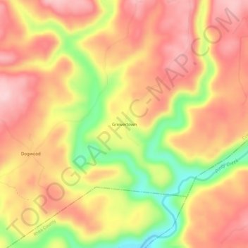
Name: Topografische Karte Greivertown, Höhe, Relief.
Durchschnittliche Höhe: 383 m
Minimale Höhe: 257 m
Maximale Höhe: 460 m
Spenden
Rüste dich für dein nächstes Abenteuer:
Als Amazon-Partner verdient diese Seite an qualifizierten Käufen, ohne dass Ihnen zusätzliche Kosten entstehen.
Andere topografische Karten
Klicken Sie auf eine Karte, um ihre Topografie, ihre Höhe und ihr Relief anzuzeigen.
Fairfield Glade
United States > Tennessee > Cumberland County > Fairfield Glade
Durchschnittliche Höhe: 542 m
Crossville
United States > Tennessee > Cumberland County
Crossville is located at the center of Cumberland County at 35°57′15″N 85°1′53″W / 35.95417°N 85.03139°W / 35.95417; -85.03139 (35.954221, -85.031267). The city is situated atop the Cumberland Plateau amidst the headwaters of the Obed River, which slices a gorge north of Crossville en…
Durchschnittliche Höhe: 553 m
Cumberland Mountain State Park
United States > Tennessee > Cumberland County > Crossville
Durchschnittliche Höhe: 554 m
Spenden
Rüste dich für dein nächstes Abenteuer:
Als Amazon-Partner verdient diese Seite an qualifizierten Käufen, ohne dass Ihnen zusätzliche Kosten entstehen.
Crossville
United States > Tennessee > Cumberland County
Crossville is located at the center of Cumberland County at 35°57′15″N 85°1′53″W / 35.95417°N 85.03139°W / 35.95417; -85.03139 (35.954221, -85.031267). The city is situated atop the Cumberland Plateau amid the headwaters of the Obed River, which slices a gorge north of Crossville en route…
Durchschnittliche Höhe: 553 m
Spenden
Rüste dich für dein nächstes Abenteuer:
Als Amazon-Partner verdient diese Seite an qualifizierten Käufen, ohne dass Ihnen zusätzliche Kosten entstehen.