
Spenden
Rüste dich für dein nächstes Abenteuer:
Als Amazon-Partner verdient diese Seite an qualifizierten Käufen, ohne dass Ihnen zusätzliche Kosten entstehen.
Topografische Karte Tingo María
Klicken Sie auf die Karte, um die Höhe anzuzeigen.
Spenden
Rüste dich für dein nächstes Abenteuer:
Als Amazon-Partner verdient diese Seite an qualifizierten Käufen, ohne dass Ihnen zusätzliche Kosten entstehen.
Tingo María
Tingo María was considered unreachable until 1936, when the Montaña Road reached the settlement. It was then that the state run Estacion Experimental Agricola was established due to its "comfortable" elevation (2,204 ft). In 1942, the U.S. Government began adding more funding to the station, and by 1960 over 40,000 acres (160 km2) of land were under cultivation, especially along the Huallaga River valley where land was level. Coffee was a particularly valuable crop. The city nickname is "the Door of the Amazonia."
Spenden
Rüste dich für dein nächstes Abenteuer:
Als Amazon-Partner verdient diese Seite an qualifizierten Käufen, ohne dass Ihnen zusätzliche Kosten entstehen.
Über diese Karte
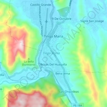
Name: Topografische Karte Tingo María, Höhe, Relief.
Ort: Tingo María, Province of Leoncio Prado, Huánuco, Peru (-9.34403 -76.01584 -9.27528 -75.98359)
Durchschnittliche Höhe: 841 m
Minimale Höhe: 632 m
Maximale Höhe: 1’472 m
Spenden
Rüste dich für dein nächstes Abenteuer:
Als Amazon-Partner verdient diese Seite an qualifizierten Käufen, ohne dass Ihnen zusätzliche Kosten entstehen.
Andere topografische Karten
Klicken Sie auf eine Karte, um ihre Topografie, ihre Höhe und ihr Relief anzuzeigen.
La Bella Durmiente
La Bella Durmiente (Spanish for Sleeping Beauty), also known as Puma Ringri (possibly from Quechua puma cougar, puma, rinri ear, "puma ear"), is a mountain and prominent feature of Tingo María National Park, in the region of Huánuco, Peru. It is located in the district of Mariano Damaso, Leoncio Prado…
Durchschnittliche Höhe: 877 m
Spenden
Rüste dich für dein nächstes Abenteuer:
Als Amazon-Partner verdient diese Seite an qualifizierten Käufen, ohne dass Ihnen zusätzliche Kosten entstehen.
Spenden
Rüste dich für dein nächstes Abenteuer:
Als Amazon-Partner verdient diese Seite an qualifizierten Käufen, ohne dass Ihnen zusätzliche Kosten entstehen.
Spenden
Rüste dich für dein nächstes Abenteuer:
Als Amazon-Partner verdient diese Seite an qualifizierten Käufen, ohne dass Ihnen zusätzliche Kosten entstehen.
Spenden
Rüste dich für dein nächstes Abenteuer:
Als Amazon-Partner verdient diese Seite an qualifizierten Käufen, ohne dass Ihnen zusätzliche Kosten entstehen.
Tingo Maria National Park
Peru > Huánuco > Mariano Dámaso Beraún
Topography in the park is steep and mountainous, because the Bella Durmiente massif occupies almost of its entire extension. Elevations in the park are in the range of 650–1808 m; rocky walls of 300–500 m in height are common. Soils are calcareous, rocky and thin, and landslides due to natural causes or…
Durchschnittliche Höhe: 1’136 m
Spenden
Rüste dich für dein nächstes Abenteuer:
Als Amazon-Partner verdient diese Seite an qualifizierten Käufen, ohne dass Ihnen zusätzliche Kosten entstehen.