Geolokalisieren
👉 Easily get elevation data in JSON, GeoTIFF and KML formats using Elevation API
Vielen Dank für die Unterstützung dieser Website ❤️
Spenden

Topografische Karte Knock

Klicken Sie auf die Karte, um die Höhe anzuzeigen.

Über diese Karte

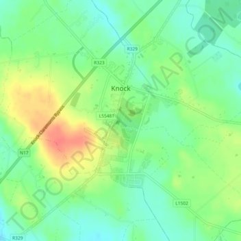
Name: Topografische Karte Knock, Höhe, Relief.

Ort: Knock, Claremorris-Swinford Municipal District, County Mayo, Connacht, F12 KF89, Ireland (53.77882 -8.93215 53.80357 -8.90282)

Durchschnittliche Höhe: 94 m

Minimale Höhe: 73 m

Maximale Höhe: 124 m

Andere topografische Karten

Klicken Sie auf eine Karte, um ihre Topografie, ihre Höhe und ihr Relief anzuzeigen.

Knockmore

Ireland > County Mayo

Durchschnittliche Höhe: 108 m

Mweelrea

Ireland > County Mayo

Durchschnittliche Höhe: 422 m

Inishbiggle

Ireland > County Mayo

Durchschnittliche Höhe: 3 m

Coogue

Ireland > County Mayo

Durchschnittliche Höhe: 100 m

Nephin

Ireland > County Mayo

In Leabhar Fiachrach, a topographical and genealogical tract written by Giolla Iosa Mor Mac Fhirbhisigh about 1400, the areas early peoples and families are listed thus.

Durchschnittliche Höhe: 404 m

Tourmakeady

Ireland > County Mayo

Durchschnittliche Höhe: 57 m

Partry

Ireland > County Mayo

Durchschnittliche Höhe: 22 m

Ballycastle

Ireland > County Mayo

Durchschnittliche Höhe: 56 m

Croagh Patrick

Ireland > County Mayo

Durchschnittliche Höhe: 314 m

Mulranny

Ireland > County Mayo

Durchschnittliche Höhe: 65 m

Westport House

Ireland > County Mayo

Durchschnittliche Höhe: 28 m

Downpatrick Head

Ireland > County Mayo

Durchschnittliche Höhe: 3 m

Cong

Ireland > County Mayo

Durchschnittliche Höhe: 23 m

Tievnabinnia

Ireland > County Mayo

Durchschnittliche Höhe: 471 m

Knock

Ireland > County Mayo

Durchschnittliche Höhe: 94 m

Glinsk

Ireland > County Mayo

Durchschnittliche Höhe: 116 m

Aghamore

Ireland > County Mayo

Durchschnittliche Höhe: 111 m

Tooreen

Ireland > County Mayo

Durchschnittliche Höhe: 97 m

Knock

Ireland > County Mayo

Durchschnittliche Höhe: 94 m

Greeve

Ireland > County Mayo

Durchschnittliche Höhe: 34 m

Wild Nephin Wilderness

Ireland > County Mayo

Durchschnittliche Höhe: 117 m

Pontoon

Ireland > County Mayo

Durchschnittliche Höhe: 26 m

Ballyglass

Ireland > County Mayo

Durchschnittliche Höhe: 40 m

Ross

Ireland > County Mayo

Durchschnittliche Höhe: 63 m

Quay Village

Ireland > County Mayo

Durchschnittliche Höhe: 24 m

Tourmakeady

Ireland > County Mayo

Durchschnittliche Höhe: 57 m

Rossport

Ireland > County Mayo

Durchschnittliche Höhe: 36 m

Ashleam

Ireland > County Mayo

Durchschnittliche Höhe: 89 m

Lough Nacorra

Ireland > County Mayo

Durchschnittliche Höhe: 207 m

Benwee Head

Ireland > County Mayo

Durchschnittliche Höhe: 54 m

Doonvinalla

Ireland > County Mayo

Durchschnittliche Höhe: 30 m

Aughagower

Ireland > County Mayo > Aughagower

Durchschnittliche Höhe: 70 m

Aghagower Round Tower

Ireland > County Mayo

Durchschnittliche Höhe: 66 m

Kilmovee

Ireland > County Mayo > Kilmovee

Durchschnittliche Höhe: 104 m

Killasser

Ireland > County Mayo

Durchschnittliche Höhe: 57 m

Bangor Erris

Ireland > County Mayo

Durchschnittliche Höhe: 71 m

Rüste dich für dein nächstes Abenteuer:

🎒Kindertragen / Kraxen - Die ganze Familie auf topografischen Entdeckungsreisen
🦶Orthopädische Einlegesohlen - Zusätzlicher Support für lange Tage auf steinigem Untergrund
🛏️Isomatten & Schlafunterlagen - Komfortable Unterlagen für erholsamen Schlaf
🚿Grosse Mikrofaser-Badetücher - Für den Sprung in den Bergsee
👒Sonnen‑Caps - Leichte Caps mit UV‑Schutz für Outdoor

Als Amazon-Partner verdient diese Seite an qualifizierten Käufen, ohne dass Ihnen zusätzliche Kosten entstehen.