
Topografische Karte Munich
Interaktive Karte
Klicken Sie auf die Karte, um die Höhe anzuzeigen.
Über diese Karte
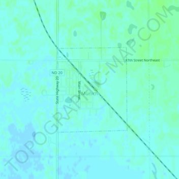
Name: Topografische Karte Munich, Höhe, Relief.
Ort: Munich, Cavalier County, North Dakota, United States (48.66332 -98.84010 48.67613 -98.82409)
Durchschnittliche Höhe: 487 m
Minimale Höhe: 484 m
Maximale Höhe: 491 m
Andere topografische Karten
Klicken Sie auf eine Karte, um ihre Topografie, ihre Höhe und ihr Relief anzuzeigen.
Langdon
United States > North Dakota > Cavalier County
Langdon, Cavalier County, North Dakota, United States
Durchschnittliche Höhe: 492 m
Calio
United States > North Dakota > Cavalier County
Calio, Cavalier County, North Dakota, United States
Durchschnittliche Höhe: 474 m
Sarles
United States > North Dakota > Cavalier County
Sarles, Cavalier County, North Dakota, United States
Durchschnittliche Höhe: 483 m
Alsen
United States > North Dakota > Cavalier County
Alsen, Cavalier County, North Dakota, United States
Durchschnittliche Höhe: 481 m
Milton
United States > North Dakota > Cavalier County
Milton, Cavalier County, North Dakota, United States
Durchschnittliche Höhe: 480 m
Calvin
United States > North Dakota > Cavalier County
Calvin, Cavalier County, North Dakota, United States
Durchschnittliche Höhe: 492 m
Loma
United States > North Dakota > Cavalier County
Loma, Cavalier County, North Dakota, United States
Durchschnittliche Höhe: 480 m
Osnabrock
United States > North Dakota > Cavalier County
Osnabrock, Cavalier County, North Dakota, United States
Durchschnittliche Höhe: 494 m
Nekoma
United States > North Dakota > Cavalier County
Nekoma, Cavalier County, North Dakota, 58355, United States
Durchschnittliche Höhe: 495 m
Hannah
United States > North Dakota > Cavalier County
Hannah, Cavalier County, North Dakota, United States
Durchschnittliche Höhe: 476 m
Wales
United States > North Dakota > Cavalier County
Wales, Cavalier County, North Dakota, United States
Durchschnittliche Höhe: 477 m