
Topografische Karte Town of Berwick
Interaktive Karte
Klicken Sie auf die Karte, um die Höhe anzuzeigen.
Über diese Karte
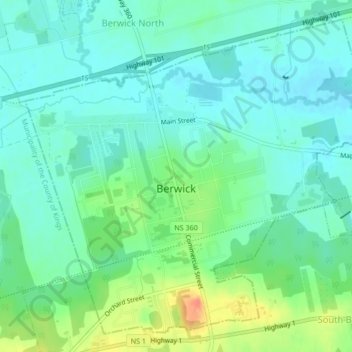
Name: Topografische Karte Town of Berwick, Höhe, Relief.
Ort: Town of Berwick, Kings County, Nova Scotia, Canada (45.03328 -64.75432 45.05988 -64.71230)
Durchschnittliche Höhe: 37 m
Minimale Höhe: 23 m
Maximale Höhe: 70 m
Andere topografische Karten
Klicken Sie auf eine Karte, um ihre Topografie, ihre Höhe und ihr Relief anzuzeigen.
Town of Kentville
Canada > Nova Scotia > Kings County
Town of Kentville, Municipality of the County of Kings, Kings County, Nova Scotia, Canada
Durchschnittliche Höhe: 64 m
Kings County
Canada > Nova Scotia > Kings County
Kings County, Nova Scotia, Canada
Durchschnittliche Höhe: 109 m
Cloud Lake
Canada > Nova Scotia > Kings County > Cloud Lake
Cloud Lake, Municipality of the County of Kings, Kings County, Nova Scotia, Canada
Durchschnittliche Höhe: 200 m
Berwick
Canada > Nova Scotia > Kings County > Berwick
Berwick, Town of Berwick, Kings County, Nova Scotia, Canada
Durchschnittliche Höhe: 37 m
Kentville
Canada > Nova Scotia > Kings County > Kentville
Kentville, Town of Kentville, Kings County, Nova Scotia, B4N 4S4, Canada
Durchschnittliche Höhe: 64 m
Canaan
Canada > Nova Scotia > Kings County > Canaan
Canaan, Municipality of the County of Kings, Kings County, Nova Scotia, Canada
Durchschnittliche Höhe: 176 m
Halls Harbour
Canada > Nova Scotia > Kings County > Halls Harbour
Halls Harbour, Municipality of the County of Kings, Kings County, Nova Scotia, Canada
Durchschnittliche Höhe: 79 m