
Topografische Karte Puthuppally
Interaktive Karte
Klicken Sie auf die Karte, um die Höhe anzuzeigen.
Über diese Karte
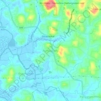
Name: Topografische Karte Puthuppally, Höhe, Relief.
Ort: Puthuppally, Kottayam, Kerala, 686011, India (9.53930 76.55194 9.57930 76.59194)
Durchschnittliche Höhe: 18 m
Minimale Höhe: -3 m
Maximale Höhe: 79 m
Andere topografische Karten
Klicken Sie auf eine Karte, um ihre Topografie, ihre Höhe und ihr Relief anzuzeigen.
Thiruvanchoor
India > Kerala > Kottayam > Thiruvanchoor
Thiruvanchoor, Kottayam, Kerala, 686637, India
Durchschnittliche Höhe: 11 m
Karappuzha Temple Kulam
India > Kerala > Kottayam > Kottayam
Karappuzha Temple Kulam, Kottayam, Kerala, India
Durchschnittliche Höhe: 6 m
Paruthumpara
Paruthumpara, Kottayam, Kerala, India
Durchschnittliche Höhe: 19 m
Mattakkara
India > Kerala > Kottayam > Mattakkara
Mattakkara, Kottayam, Kerala, 686564, India
Durchschnittliche Höhe: 41 m