
Topografische Karte Cape Willoughby Conservation Park
Interaktive Karte
Klicken Sie auf die Karte, um die Höhe anzuzeigen.
Über diese Karte
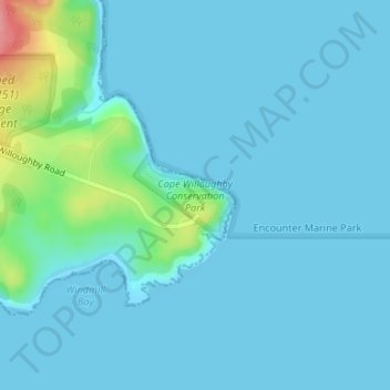
Name: Topografische Karte Cape Willoughby Conservation Park, Höhe, Relief.
Durchschnittliche Höhe: 12 m
Minimale Höhe: 0 m
Maximale Höhe: 98 m
Andere topografische Karten
Klicken Sie auf eine Karte, um ihre Topografie, ihre Höhe und ihr Relief anzuzeigen.
Kangaroo Island
Australia > South Australia > Kangaroo Island Council
Kangaroo Island, Kangaroo Island Council, South Australia, Australia
Durchschnittliche Höhe: 22 m
Flinders Chase
Australia > South Australia > Kangaroo Island Council
Flinders Chase, Kangaroo Island Council, South Australia, 5223, Australia
Durchschnittliche Höhe: 94 m
American River
Australia > South Australia > Kangaroo Island Council
American River, Kangaroo Island Council, South Australia, 5221, Australia
Durchschnittliche Höhe: 30 m
Wisanger
Australia > South Australia > Kangaroo Island Council
Wisanger, Kangaroo Island Council, South Australia, 5223, Australia
Durchschnittliche Höhe: 38 m
Kingscote
Australia > South Australia > Kangaroo Island Council
Kingscote, Kangaroo Island Council, South Australia, 5223, Australia
Durchschnittliche Höhe: 7 m
Nepean Bay
Australia > South Australia > Kangaroo Island Council
Nepean Bay, Kangaroo Island Council, South Australia, 5223, Australia
Durchschnittliche Höhe: 25 m