
Spenden
Rüste dich für dein nächstes Abenteuer:
Als Amazon-Partner verdient diese Seite an qualifizierten Käufen, ohne dass Ihnen zusätzliche Kosten entstehen.
Topografische Karte Bixby
Klicken Sie auf die Karte, um die Höhe anzuzeigen.
Spenden
Rüste dich für dein nächstes Abenteuer:
Als Amazon-Partner verdient diese Seite an qualifizierten Käufen, ohne dass Ihnen zusätzliche Kosten entstehen.
Bixby
Bixby is located at 35°57′39″N 95°52′42″W / 35.96083°N 95.87833°W / 35.96083; -95.87833 (35.960898, −95.878258). According to the United States Census Bureau, the city has a total area of 25.1 square miles (65.0 km2), of which 24.0 square miles (62.3 km2) is land and 1.0 square mile (2.7 km2) (4.15%) is water. The average elevation is 750 ft (230 m) above MSL. The town is bisected into north and south portions by the Arkansas River; the original town center is located south of the river.
Spenden
Rüste dich für dein nächstes Abenteuer:
Als Amazon-Partner verdient diese Seite an qualifizierten Käufen, ohne dass Ihnen zusätzliche Kosten entstehen.
Über diese Karte
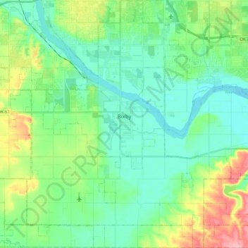
Name: Topografische Karte Bixby, Höhe, Relief.
Ort: Bixby, Tulsa County, Oklahoma, 74008, United States (35.85590 -95.96187 36.01739 -95.76210)
Durchschnittliche Höhe: 204 m
Minimale Höhe: 171 m
Maximale Höhe: 294 m
Spenden
Rüste dich für dein nächstes Abenteuer:
Als Amazon-Partner verdient diese Seite an qualifizierten Käufen, ohne dass Ihnen zusätzliche Kosten entstehen.
Andere topografische Karten
Klicken Sie auf eine Karte, um ihre Topografie, ihre Höhe und ihr Relief anzuzeigen.