
Topografische Karte Salt Lake City
Interaktive Karte
Klicken Sie auf die Karte, um die Höhe anzuzeigen.
Über diese Karte
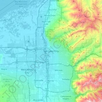
Name: Topografische Karte Salt Lake City, Höhe, Relief.
Durchschnittliche Höhe: 1’625 m
Minimale Höhe: 1’278 m
Maximale Höhe: 3’231 m
Salt Lake City has an area of 110.4 square miles (286 km2) and an average elevation of 4,327 feet (1,319 m) above sea level. The lowest point within the boundaries of the city is 4,210 feet (1,280 m) near the Jordan River and the Great Salt Lake, and the highest is Grandview Peak, at 9,410 feet (2,868 m).