
Spenden
Rüste dich für dein nächstes Abenteuer:
Als Amazon-Partner verdient diese Seite an qualifizierten Käufen, ohne dass Ihnen zusätzliche Kosten entstehen.
Topografische Karte Villalba
Klicken Sie auf die Karte, um die Höhe anzuzeigen.
Spenden
Rüste dich für dein nächstes Abenteuer:
Als Amazon-Partner verdient diese Seite an qualifizierten Käufen, ohne dass Ihnen zusätzliche Kosten entstehen.
Villalba
Villalba is located in the central region of Puerto Rico, on a valley in the Cordillera Central. The highest point in the municipality is Cerro El Bolo at 3,526 feet (1,075 m) of elevation.
Spenden
Rüste dich für dein nächstes Abenteuer:
Als Amazon-Partner verdient diese Seite an qualifizierten Käufen, ohne dass Ihnen zusätzliche Kosten entstehen.
Über diese Karte
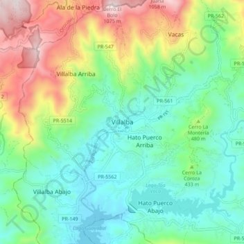
Name: Topografische Karte Villalba, Höhe, Relief.
Ort: Villalba, Puerto Rico, 00766, United States (18.08835 -66.53250 18.16835 -66.45250)
Durchschnittliche Höhe: 406 m
Minimale Höhe: 97 m
Maximale Höhe: 1’086 m
Spenden
Rüste dich für dein nächstes Abenteuer:
Als Amazon-Partner verdient diese Seite an qualifizierten Käufen, ohne dass Ihnen zusätzliche Kosten entstehen.