
Topografische Karte Jejuri
Interaktive Karte
Klicken Sie auf die Karte, um die Höhe anzuzeigen.
Über diese Karte
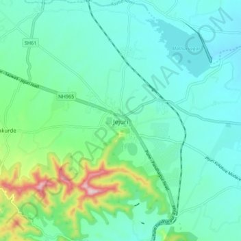
Name: Topografische Karte Jejuri, Höhe, Relief.
Ort: Jejuri, Purandhar, Pune, Maharashtra, 412303, India (18.23690 74.12023 18.31690 74.20023)
Durchschnittliche Höhe: 728 m
Minimale Höhe: 659 m
Maximale Höhe: 994 m
Jejuri is located at 18°17′N 74°10′E / 18.28°N 74.17°E / 18.28; 74.17. It has an average elevation of 718 metres (2355 feet) mean sea level.
Andere topografische Karten
Klicken Sie auf eine Karte, um ihre Topografie, ihre Höhe und ihr Relief anzuzeigen.
Malhargad Fort
India > Maharashtra > Purandhar
Malhargad Fort, Malhargad Walking Path, Purandhar, Pune District, Maharashtra, India
Durchschnittliche Höhe: 822 m
Garade
India > Maharashtra > Purandhar
Garade, Purandhar, Pune, Maharashtra, 412205, India
Durchschnittliche Höhe: 883 m
Saswad
India > Maharashtra > Purandhar
Saswad, Purandhar, Pune, Maharashtra, 412300, India
Durchschnittliche Höhe: 787 m
Narayanpur
India > Maharashtra > Purandhar
Narayanpur, Purandhar, Maharashtra, 412302, India
Durchschnittliche Höhe: 924 m
Kalewadi
India > Maharashtra > Purandhar
Kalewadi, Purandhar, Pune, Maharashtra, India
Durchschnittliche Höhe: 839 m
Ketkawale
India > Maharashtra > Purandhar
Ketkawale, Purandhar, Pune, Maharashtra, 412302, India
Durchschnittliche Höhe: 754 m