
Spenden
Rüste dich für dein nächstes Abenteuer:
Als Amazon-Partner verdient diese Seite an qualifizierten Käufen, ohne dass Ihnen zusätzliche Kosten entstehen.
Topografische Karte Roselle
Klicken Sie auf die Karte, um die Höhe anzuzeigen.
Spenden
Rüste dich für dein nächstes Abenteuer:
Als Amazon-Partner verdient diese Seite an qualifizierten Käufen, ohne dass Ihnen zusätzliche Kosten entstehen.
Über diese Karte
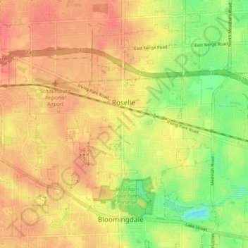
Name: Topografische Karte Roselle, Höhe, Relief.
Ort: Roselle, DuPage County, Illinois, United States (41.95973 -88.12581 42.00044 -88.04652)
Durchschnittliche Höhe: 235 m
Minimale Höhe: 203 m
Maximale Höhe: 254 m
Spenden
Rüste dich für dein nächstes Abenteuer:
Als Amazon-Partner verdient diese Seite an qualifizierten Käufen, ohne dass Ihnen zusätzliche Kosten entstehen.
Andere topografische Karten
Klicken Sie auf eine Karte, um ihre Topografie, ihre Höhe und ihr Relief anzuzeigen.
Elmhurst
United States > Illinois > DuPage County
Due to local topography, the town has had a tendency to flood in the past after large rainfalls; the city is currently undertaking a large effort to mitigate future flooding.
Durchschnittliche Höhe: 207 m
Elmhurst
United States > Illinois > DuPage County
Due to local topography, the town has had a tendency to flood in the past after large rainfalls; the city is currently undertaking a large effort to mitigate future flooding.
Durchschnittliche Höhe: 207 m
Spenden
Rüste dich für dein nächstes Abenteuer:
Als Amazon-Partner verdient diese Seite an qualifizierten Käufen, ohne dass Ihnen zusätzliche Kosten entstehen.
Glen Ellyn Manor Park
United States > Illinois > DuPage County > Glen Ellyn
Durchschnittliche Höhe: 235 m