
Topografische Karte Golan Heights
Interaktive Karte
Klicken Sie auf die Karte, um die Höhe anzuzeigen.
Über diese Karte
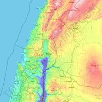
Name: Topografische Karte Golan Heights, Höhe, Relief.
Durchschnittliche Höhe: 533 m
Minimale Höhe: -357 m
Maximale Höhe: 2’777 m
The plateau that Israel controls is part of a larger area of volcanic basalt fields stretching north and east that were created in the series of volcanic eruptions that began recently in geological terms, almost 4 million years ago. The rock forming the mountainous area in the northern Golan Heights, descending from Mount Hermon, differs geologically from the volcanic rocks of the plateau and has a different physiography. The mountains are characterised by lighter-colored, Jurassic-age limestone of sedimentary origin. Locally, the limestone is broken by faults and solution channels to form a karst-like topography in which springs are common.
Andere topografische Karten
Klicken Sie auf eine Karte, um ihre Topografie, ihre Höhe und ihr Relief anzuzeigen.
Avnay Eitan
Israel > North District > Golan Regional Council
Avnay Eitan, Golan Regional Council, Golan Subdistrict, North District, Israel
Durchschnittliche Höhe: 384 m
Ein Zivan
Israel > North District > Golan Regional Council
Ein Zivan, Golan Regional Council, Golan Subdistrict, North District, Israel
Durchschnittliche Höhe: 948 m
Mount Hermon
Israel > North District > Golan Regional Council
Mount Hermon, Golan Regional Council, Golan Subdistrict, North District, Israel
Durchschnittliche Höhe: 1’741 m
Neve Ativ
Israel > North District > Golan Regional Council
Neve Ativ, Golan Regional Council, Golan Subdistrict, North District, Israel
Durchschnittliche Höhe: 1’012 m
Givat Yoav
Israel > North District > Golan Regional Council
Givat Yoav, Golan Regional Council, Golan Subdistrict, North District, Israel
Durchschnittliche Höhe: 245 m
Mt. Hermon
Israel > North District > Golan Regional Council
Mt. Hermon, Golan Regional Council, North District, Israel
Durchschnittliche Höhe: 2’016 m
Golan Heights
Israel > North District > Golan Regional Council
Golan Heights, Golan Regional Council, Golan Heights Subdistrict, North District, Israel
Durchschnittliche Höhe: 533 m
Ophir Viewpoint
Israel > North District > Golan Regional Council
Ophir Viewpoint, 789, Golan Regional Council, Golan Heights Subdistrict, North District, no, Israel
Durchschnittliche Höhe: 40 m
Koorsi national park
Israel > North District > Golan Regional Council
Koorsi national park, Golan Regional Council, Golan Heights Subdistrict, North District, no, Israel
Durchschnittliche Höhe: -138 m