
Topografische Karte Khao Wua–Phloi Waen
Interaktive Karte
Klicken Sie auf die Karte, um die Höhe anzuzeigen.
Über diese Karte
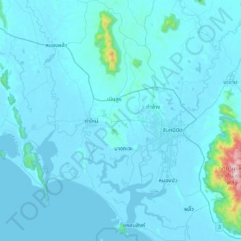
Name: Topografische Karte Khao Wua–Phloi Waen, Höhe, Relief.
Ort: Khao Wua–Phloi Waen, Chanthaburi Province, 22120, Thailand (12.46219 101.88896 12.78219 102.20896)
Durchschnittliche Höhe: 37 m
Minimale Höhe: -3 m
Maximale Höhe: 915 m
Andere topografische Karten
Klicken Sie auf eine Karte, um ihre Topografie, ihre Höhe und ihr Relief anzuzeigen.
Bang Kacha
Thailand > Chanthaburi Province
Bang Kacha, Khai Noen Wong, Chanthaburi Province, 22120, Thailand
Durchschnittliche Höhe: 9 m
Na Yai Am
Thailand > Chanthaburi Province
Na Yai Am, Chang Kham, Chanthaburi Province, 22160, Thailand
Durchschnittliche Höhe: 13 m
Khlong Phlu
Thailand > Chanthaburi Province
Khlong Phlu, Chanthaburi Province, Thailand
Durchschnittliche Höhe: 238 m
Khao Baisi
Thailand > Chanthaburi Province
Khao Baisi, Chanthaburi Province, 22120, Thailand
Durchschnittliche Höhe: 19 m
Phlapphla
Thailand > Chanthaburi Province
Phlapphla, Chanthaburi Province, 22000, Thailand
Durchschnittliche Höhe: 59 m
Laem Sing
Thailand > Chanthaburi Province
Laem Sing, Ko Khwang, Chanthaburi Province, Thailand
Durchschnittliche Höhe: 2 m
Phlio
Thailand > Chanthaburi Province
Phlio, Kwian Hak, Chanthaburi Province, Thailand
Durchschnittliche Höhe: 18 m
Soi Dao
Thailand > Chanthaburi Province
Soi Dao, Chanthaburi Province, Thailand
Durchschnittliche Höhe: 274 m
Tha Chang
Thailand > Chanthaburi Province
Tha Chang, Salaeng, Chanthaburi Province, Thailand
Durchschnittliche Höhe: 16 m
Pluang Dam
Thailand > Chanthaburi Province
Pluang Dam, Wang Saem, Chanthaburi Province, Thailand
Durchschnittliche Höhe: 63 m
Chanthaburi
Thailand > Chanthaburi Province
Chanthaburi, Phlapphla Narai, Chanthaburi Province, 22000, Thailand
Durchschnittliche Höhe: 7 m
Sanam Chai
Thailand > Chanthaburi Province
Sanam Chai, Chanthaburi Province, Thailand
Durchschnittliche Höhe: 12 m