
Topografische Karte Fort Mill
Interaktive Karte
Klicken Sie auf die Karte, um die Höhe anzuzeigen.
Über diese Karte
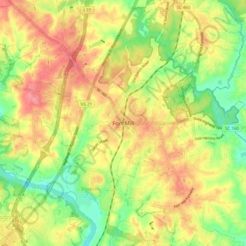
Name: Topografische Karte Fort Mill, Höhe, Relief.
Ort: Fort Mill, York County, South Carolina, 29716, United States (34.96737 -80.98508 35.04737 -80.90508)
Durchschnittliche Höhe: 182 m
Minimale Höhe: 142 m
Maximale Höhe: 218 m
Andere topografische Karten
Klicken Sie auf eine Karte, um ihre Topografie, ihre Höhe und ihr Relief anzuzeigen.
Old Orchid
United States > South Carolina > York County > Fort Mill > Old Orchid
Old Orchid, Fort Mill, York County, South Carolina, 29715, United States
Durchschnittliche Höhe: 184 m