
Spenden
Rüste dich für dein nächstes Abenteuer:
Als Amazon-Partner verdient diese Seite an qualifizierten Käufen, ohne dass Ihnen zusätzliche Kosten entstehen.
Topografische Karte Blairsville
Klicken Sie auf die Karte, um die Höhe anzuzeigen.
Spenden
Rüste dich für dein nächstes Abenteuer:
Als Amazon-Partner verdient diese Seite an qualifizierten Käufen, ohne dass Ihnen zusätzliche Kosten entstehen.
Blairsville
Blairsville, Georgia, is situated in the picturesque Appalachian Mountains, characterized by a varied topography that includes rolling hills, lush valleys, and prominent mountain ridges. The elevation of the town itself is approximately 1,800 feet, providing breathtaking views of the surrounding landscape. The area is intersected by numerous creeks and streams, which contribute to the rich biodiversity and vibrant ecosystems. Nearby, the towering peaks of the Blue Ridge Mountains can reach elevations over 4,000 feet, creating a dramatic backdrop and offering numerous hiking trails that meander through dense forests and alongside serene lakes. This mountainous terrain, combined with its fertile valleys, makes Blairsville a striking example of North Georgia's natural beauty, appealing to outdoor enthusiasts and nature lovers alike.
Spenden
Rüste dich für dein nächstes Abenteuer:
Als Amazon-Partner verdient diese Seite an qualifizierten Käufen, ohne dass Ihnen zusätzliche Kosten entstehen.
Über diese Karte
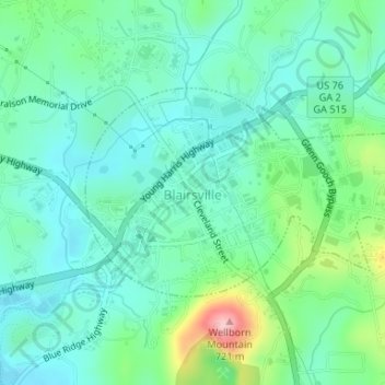
Name: Topografische Karte Blairsville, Höhe, Relief.
Ort: Blairsville, Union County, Georgia, United States (34.86877 -83.96754 34.88341 -83.93990)
Durchschnittliche Höhe: 587 m
Minimale Höhe: 542 m
Maximale Höhe: 726 m
Spenden
Rüste dich für dein nächstes Abenteuer:
Als Amazon-Partner verdient diese Seite an qualifizierten Käufen, ohne dass Ihnen zusätzliche Kosten entstehen.
Andere topografische Karten
Klicken Sie auf eine Karte, um ihre Topografie, ihre Höhe und ihr Relief anzuzeigen.
Blood Mountain
United States > Georgia > Union County
Blood Mountain is the highest peak on the Georgia section of the Appalachian Trail and the sixth-tallest mountain in Georgia, with an elevation of 4,458 feet (1,359 m). It is located on the border of Lumpkin County with Union County and is within the boundaries of the Chattahoochee National Forest and the…
Durchschnittliche Höhe: 1’048 m
Spenden
Rüste dich für dein nächstes Abenteuer:
Als Amazon-Partner verdient diese Seite an qualifizierten Käufen, ohne dass Ihnen zusätzliche Kosten entstehen.