
Topografische Karte Rügen
Interaktive Karte
Klicken Sie auf die Karte, um die Höhe anzuzeigen.
Über diese Karte
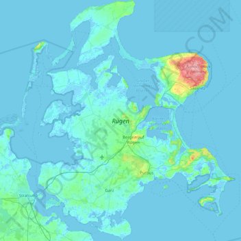
Name: Topografische Karte Rügen, Höhe, Relief.
Durchschnittliche Höhe: 7 m
Minimale Höhe: -5 m
Maximale Höhe: 163 m
Rügen has a total area of 926.4 km2 (357.7 sq mi), or 974 km2 (376 sq mi) if the adjacent small islands are included. The maximum diameter is 51.4 km (31.9 mi) from north to south, and 42.8 km (26.6 mi) from east to west. Of an overall 574 km (357 mi)-long coastline, 56 km (35 mi) are sandy Baltic Sea beaches, and 2.8 km (1.7 mi) sandy bodden beaches. The highest elevations are on the Jasmund peninsula: Piekberg (161 m (528 ft)) and Königsstuhl (117 m (384 ft)).