
Spenden
Rüste dich für dein nächstes Abenteuer:
Als Amazon-Partner verdient diese Seite an qualifizierten Käufen, ohne dass Ihnen zusätzliche Kosten entstehen.
Topografische Karte Trapper Creek
Klicken Sie auf die Karte, um die Höhe anzuzeigen.
Spenden
Rüste dich für dein nächstes Abenteuer:
Als Amazon-Partner verdient diese Seite an qualifizierten Käufen, ohne dass Ihnen zusätzliche Kosten entstehen.
Trapper Creek
Trapper Creek is a community located in Matanuska-Susitna Borough at latitude 62.317 and longitude -150.231, with an elevation of 351 ft (107 m). It is at mile 114.5 on the Parks Highway, just south of Denali State Park. Trapper Creek is found at the intersection of Petersville Road and is spread out along the Parks Highway 15 miles (24 km) north of Talkeetna Junction. The Trapper Creek CDP extends west down the Petersville Road, which leads to mining, prospecting, and recreation country in the foothills of the Alaska Range.
Spenden
Rüste dich für dein nächstes Abenteuer:
Als Amazon-Partner verdient diese Seite an qualifizierten Käufen, ohne dass Ihnen zusätzliche Kosten entstehen.
Über diese Karte
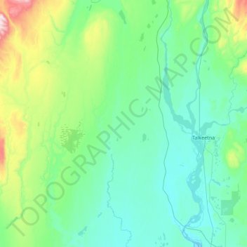
Name: Topografische Karte Trapper Creek, Höhe, Relief.
Durchschnittliche Höhe: 235 m
Minimale Höhe: 76 m
Maximale Höhe: 1’080 m
Spenden
Rüste dich für dein nächstes Abenteuer:
Als Amazon-Partner verdient diese Seite an qualifizierten Käufen, ohne dass Ihnen zusätzliche Kosten entstehen.
Andere topografische Karten
Klicken Sie auf eine Karte, um ihre Topografie, ihre Höhe und ihr Relief anzuzeigen.
Willow
United States > Alaska > Matanuska-Susitna Borough
Willow has a subarctic climate with long and cold winters and mild summers. Whites Crossing is a weather station near Willow, situated at an elevation of 270 ft (82 m).
Durchschnittliche Höhe: 69 m
Spenden
Rüste dich für dein nächstes Abenteuer:
Als Amazon-Partner verdient diese Seite an qualifizierten Käufen, ohne dass Ihnen zusätzliche Kosten entstehen.
Spenden
Rüste dich für dein nächstes Abenteuer:
Als Amazon-Partner verdient diese Seite an qualifizierten Käufen, ohne dass Ihnen zusätzliche Kosten entstehen.
Denali State Park
United States > Alaska > Matanuska-Susitna Borough
Denali State Park is in sight of Denali, the highest mountain peak in North America, with a summit elevation of 20,310 feet above sea level. Denali rises 18,000 feet from base to peak, making it the largest mountain situated entirely above sea level. To the east, the state park borders the Susitna River, which…
Durchschnittliche Höhe: 702 m
Spenden
Rüste dich für dein nächstes Abenteuer:
Als Amazon-Partner verdient diese Seite an qualifizierten Käufen, ohne dass Ihnen zusätzliche Kosten entstehen.
Lazy Mountain
United States > Alaska > Matanuska-Susitna Borough > Sutton
Durchschnittliche Höhe: 433 m