
Spenden
Rüste dich für dein nächstes Abenteuer:
Als Amazon-Partner verdient diese Seite an qualifizierten Käufen, ohne dass Ihnen zusätzliche Kosten entstehen.
Topografische Karte Saint Ignatius
Klicken Sie auf die Karte, um die Höhe anzuzeigen.
Spenden
Rüste dich für dein nächstes Abenteuer:
Als Amazon-Partner verdient diese Seite an qualifizierten Käufen, ohne dass Ihnen zusätzliche Kosten entstehen.
Über diese Karte
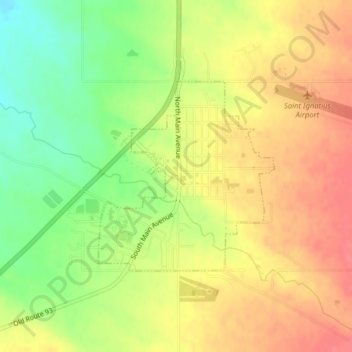
Name: Topografische Karte Saint Ignatius, Höhe, Relief.
Ort: Saint Ignatius, Lake County, Montana, United States (47.31218 -114.10585 47.32670 -114.08591)
Durchschnittliche Höhe: 893 m
Minimale Höhe: 857 m
Maximale Höhe: 919 m
Spenden
Rüste dich für dein nächstes Abenteuer:
Als Amazon-Partner verdient diese Seite an qualifizierten Käufen, ohne dass Ihnen zusätzliche Kosten entstehen.
Andere topografische Karten
Klicken Sie auf eine Karte, um ihre Topografie, ihre Höhe und ihr Relief anzuzeigen.
Wild Horse Island
United States > Montana > Lake County
The island was formed by the Cordilleran Glacier, giving the island a varying topography. Its shores are 2,900 feet (880 m) above sea level. The glacier caused the six summits in the center of the island, ranging in heights between 3,277 and 3,745 feet (999 and 1,141 m), to be formed into rôche moutonnée,…
Durchschnittliche Höhe: 916 m