
Topografische Karte Thompson Falls
Interaktive Karte
Klicken Sie auf die Karte, um die Höhe anzuzeigen.
Über diese Karte
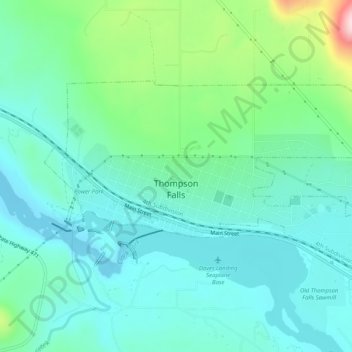
Name: Topografische Karte Thompson Falls, Höhe, Relief.
Durchschnittliche Höhe: 782 m
Minimale Höhe: 713 m
Maximale Höhe: 1’022 m
Thompson Falls is located at 47°35′48″N 115°20′37″W / 47.59667°N 115.34361°W / 47.59667; -115.34361 (47.596587, -115.343730) in the Clark Fork Valley at an elevation of 2,419 feet (737 m).
Andere topografische Karten
Klicken Sie auf eine Karte, um ihre Topografie, ihre Höhe und ihr Relief anzuzeigen.
Weeksville
United States > Montana > Sanders County
Weeksville, Sanders County, Montana, United States
Durchschnittliche Höhe: 864 m
Heron
United States > Montana > Sanders County
Heron, Sanders County, Montana, United States
Durchschnittliche Höhe: 762 m
Paradise
United States > Montana > Sanders County
Paradise, Sanders County, Montana, United States
Durchschnittliche Höhe: 881 m
Plains
United States > Montana > Sanders County > Plains
Plains, Sanders County, Montana, United States
Durchschnittliche Höhe: 775 m
Thompson Falls
United States > Montana > Sanders County > Thompson Falls
Thompson Falls, Sanders County, Montana, 59873, United States
Durchschnittliche Höhe: 897 m