Topografische Karte County Offaly
Interaktive Karte
Klicken Sie auf die Karte, um die Höhe anzuzeigen.
Über diese Karte
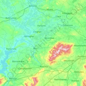
Name: Topografische Karte County Offaly, Höhe, Relief.
Ort: County Offaly, Leinster, R45 X951, Irland (52.84813 -8.08365 53.42427 -6.97776)
Durchschnittliche Höhe: 91 m
Minimale Höhe: 27 m
Maximale Höhe: 512 m
Andere topografische Karten
Klicken Sie auf eine Karte, um ihre Topografie, ihre Höhe und ihr Relief anzuzeigen.
Lower Lough Bray
Lower Lough Bray, Powerscourt ED, The Municipal District of Bray, County Wicklow, Leinster, Irland
Durchschnittliche Höhe: 455 m
Castleknock
Castleknock, Fingal, Dublin 15, Leinster, D15 VY32, Irland
Durchschnittliche Höhe: 55 m
Eagle's Crag
Eagle's Crag, Powerscourt ED, The Municipal District of Bray, County Wicklow, Leinster, Irland
Durchschnittliche Höhe: 490 m
The Municipal District of Wicklow
The Municipal District of Wicklow, County Wicklow, Leinster, Irland
Durchschnittliche Höhe: 263 m
Glencullen ED
Glencullen ED, Dublin 18, Dún Laoghaire-Rathdown, County Dublin, Leinster, Irland
Durchschnittliche Höhe: 137 m
Dingle - Daingean Uí Chúis
Irland > Dingle - Daingean Uí Chúis
Dingle - Daingean Uí Chúis, County Kerry, Munster, Irland
Durchschnittliche Höhe: 77 m
Attimonmore South
Attimonmore South, Cloonkeen ED, Athenry-Oranmore Municipal District, County Galway, Connacht, Irland
Durchschnittliche Höhe: 75 m
North Bull Island
North Bull Island, Raheny St. Assam ED, Dublin 5, Dublin, County Dublin, Leinster, Irland
Durchschnittliche Höhe: 2 m
Valentia Island
Valentia Island, Kenmare Municipal District, County Kerry, Munster, Irland
Durchschnittliche Höhe: 39 m