
Topografische Karte Frisco
Interaktive Karte
Klicken Sie auf die Karte, um die Höhe anzuzeigen.
Frisco
In 1902, a line of the St. Louis-San Francisco Railway was being built through the area, and periodic watering stops were needed along the route for the steam locomotives. The current settlement of Lebanon was on the Preston Ridge, and was too high in elevation, so the watering stop was placed about 4 miles (6 km) to the west on lower ground. A community grew around this train stop. Some Lebanon residents moved their houses to the new community on logs. The new town was originally named Emerson, but the U.S. Postal Service rejected the name as too similar to another community, Emberson, in Lamar County.
Über diese Karte
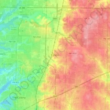
Name: Topografische Karte Frisco, Höhe, Relief.
Ort: Frisco, Collin County, Texas, United States (33.08150 -96.92279 33.21958 -96.73257)
Durchschnittliche Höhe: 201 m
Minimale Höhe: 152 m
Maximale Höhe: 247 m
Andere topografische Karten
Klicken Sie auf eine Karte, um ihre Topografie, ihre Höhe und ihr Relief anzuzeigen.
Frisco
United States > Texas > Collin County > Frisco
When the Dallas area was being settled by American pioneers, many of the settlers traveled by wagon trains along the Shawnee Trail. This trail became the Preston Trail, and later, Preston Road. With all of this activity, the community of Lebanon was founded along this trail, and was granted a U.S. post office…
Durchschnittliche Höhe: 191 m
Plano
United States > Texas > Collin County > Plano
At first, Plano's population grew slowly, reaching 1,304 in 1900 and 3,695 in 1960. By 1970, Plano began to feel some of the boom its neighbors had experienced after World War II. A series of public works projects and a change in taxes that removed the farming community from the town helped increase the…
Durchschnittliche Höhe: 181 m
Lavon Beach Estates
United States > Texas > Collin County > Lavon Beach Estates
Durchschnittliche Höhe: 154 m