Topografische Karten Navarro County
Klicken Sie auf eine Karte, um ihre Topografie, ihre Höhe und ihr Relief anzuzeigen.


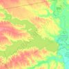
Richland-Chambers Reservoir
United States > Texas > Navarro County > Eureka
The project was designed and engineered by Freese and Nichols, Consulting Engineers, of Fort Worth, Texas. Bill Johnson and a team, from Buce and Gunn, provided the necessary topography and surveying, for the project. Construction began on October 7, 1982. The dam was closed on Richland-Chambers Reservoir July…
Durchschnittliche Höhe: 100 m