
Spenden
Rüste dich für dein nächstes Abenteuer:
Als Amazon-Partner verdient diese Seite an qualifizierten Käufen, ohne dass Ihnen zusätzliche Kosten entstehen.
Topografische Karte Albertville
Klicken Sie auf die Karte, um die Höhe anzuzeigen.
Spenden
Rüste dich für dein nächstes Abenteuer:
Als Amazon-Partner verdient diese Seite an qualifizierten Käufen, ohne dass Ihnen zusätzliche Kosten entstehen.
Albertville
The city sits at an elevation of 1,060 feet (320 m) atop Sand Mountain, a plateau that in this area is about 15 miles (24 km) wide. The Tennessee Valley Divide passes through the southern part of the city. The majority of the city drains north to Short Creek, a tributary of the Tennessee River, while the southern part drains to Slab Creek, a west-flowing tributary of the Locust Fork of the Black Warrior River. The current slogan of Albertville is "The Heart of Sand Mountain", which can be seen on the welcome sign coming into the city.
Spenden
Rüste dich für dein nächstes Abenteuer:
Als Amazon-Partner verdient diese Seite an qualifizierten Käufen, ohne dass Ihnen zusätzliche Kosten entstehen.
Über diese Karte
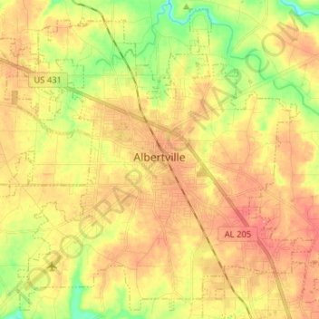
Name: Topografische Karte Albertville, Höhe, Relief.
Ort: Albertville, Marshall County, Alabama, 35950, United States (34.21637 -86.27448 34.31681 -86.14596)
Durchschnittliche Höhe: 309 m
Minimale Höhe: 254 m
Maximale Höhe: 356 m
Spenden
Rüste dich für dein nächstes Abenteuer:
Als Amazon-Partner verdient diese Seite an qualifizierten Käufen, ohne dass Ihnen zusätzliche Kosten entstehen.
Andere topografische Karten
Klicken Sie auf eine Karte, um ihre Topografie, ihre Höhe und ihr Relief anzuzeigen.
Little New York
United States > Alabama > Marshall County > Guntersville
Durchschnittliche Höhe: 277 m
Spenden
Rüste dich für dein nächstes Abenteuer:
Als Amazon-Partner verdient diese Seite an qualifizierten Käufen, ohne dass Ihnen zusätzliche Kosten entstehen.