
Spenden
Rüste dich für dein nächstes Abenteuer:
Als Amazon-Partner verdient diese Seite an qualifizierten Käufen, ohne dass Ihnen zusätzliche Kosten entstehen.
Topografische Karte Grassy
Klicken Sie auf die Karte, um die Höhe anzuzeigen.
Spenden
Rüste dich für dein nächstes Abenteuer:
Als Amazon-Partner verdient diese Seite an qualifizierten Käufen, ohne dass Ihnen zusätzliche Kosten entstehen.
Über diese Karte
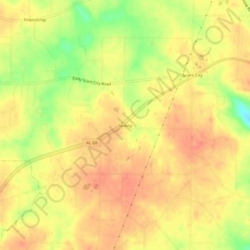
Name: Topografische Karte Grassy, Höhe, Relief.
Ort: Grassy, Marshall County, Alabama, United States (34.33426 -86.45665 34.37426 -86.41665)
Durchschnittliche Höhe: 309 m
Minimale Höhe: 272 m
Maximale Höhe: 326 m
Spenden
Rüste dich für dein nächstes Abenteuer:
Als Amazon-Partner verdient diese Seite an qualifizierten Käufen, ohne dass Ihnen zusätzliche Kosten entstehen.
Andere topografische Karten
Klicken Sie auf eine Karte, um ihre Topografie, ihre Höhe und ihr Relief anzuzeigen.
Arab
United States > Alabama > Marshall County
Arab is located at an elevation of 1,100 feet (340 m) on top of Brindlee Mountain, near the southwest end of the Appalachian Plateau. The city is primarily in southern Marshall County; a small portion extends south into Cullman County. U.S. Route 231 runs north-to-south through Arab, and State Route 69 runs…
Durchschnittliche Höhe: 314 m
Albertville
United States > Alabama > Marshall County
According to the U.S. Census Bureau, Albertville has a total area of 27.0 square miles (69.9 km2), of which 0.1 square miles (0.3 km2), or 0.37%, are water. The city sits at an elevation of 1,060 feet (320 m) atop Sand Mountain, a plateau that in this area is about 15 miles (24 km) wide. The Tennessee Valley…
Durchschnittliche Höhe: 309 m
Albertville
United States > Alabama > Marshall County
The city sits at an elevation of 1,060 feet (320 m) atop Sand Mountain, a plateau that in this area is about 15 miles (24 km) wide. The Tennessee Valley Divide passes through the southern part of the city. The majority of the city drains north to Short Creek, a tributary of the Tennessee River, while the…
Durchschnittliche Höhe: 309 m
Spenden
Rüste dich für dein nächstes Abenteuer:
Als Amazon-Partner verdient diese Seite an qualifizierten Käufen, ohne dass Ihnen zusätzliche Kosten entstehen.
Arab
United States > Alabama > Marshall County
Arab is located at an elevation of 1,100 feet (340 m) on top of Brindlee Mountain, near the southwest end of the Appalachian Plateau. The city is primarily in southern Marshall County; a small portion extends south into Cullman County. U.S. Route 231 runs north-to-south through Arab, and State Route 69 runs…
Durchschnittliche Höhe: 314 m
Albertville
United States > Alabama > Marshall County
The city sits at an elevation of 1,060 feet (320 m) atop Sand Mountain, a plateau that in this area is about 15 miles (24 km) wide. The Tennessee Valley Divide passes through the southern part of the city. The majority of the city drains north to Short Creek, a tributary of the Tennessee River, while the…
Durchschnittliche Höhe: 309 m