
Topografische Karte Cloud Peak Glacier
Interaktive Karte
Klicken Sie auf die Karte, um die Höhe anzuzeigen.
Über diese Karte
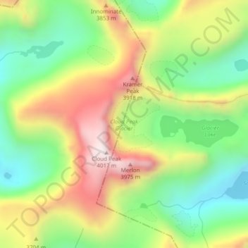
Name: Topografische Karte Cloud Peak Glacier, Höhe, Relief.
Ort: Cloud Peak Glacier, Johnson County, Wyoming, United States (44.38221 -107.17311 44.38824 -107.16584)
Durchschnittliche Höhe: 3’603 m
Minimale Höhe: 3’287 m
Maximale Höhe: 4’016 m
Andere topografische Karten
Klicken Sie auf eine Karte, um ihre Topografie, ihre Höhe und ihr Relief anzuzeigen.
Buffalo
United States > Wyoming > Johnson County
Buffalo, Johnson County, Wyoming, 82834, United States
Durchschnittliche Höhe: 1’437 m
Kaycee
United States > Wyoming > Johnson County
Kaycee, Johnson County, Wyoming, United States
Durchschnittliche Höhe: 1’431 m
Buffalo
United States > Wyoming > Johnson County
Buffalo, Johnson County, Wyoming, 82834, United States
Durchschnittliche Höhe: 1’442 m
Gardner Mountain
United States > Wyoming > Johnson County
Gardner Mountain, Johnson County, Wyoming, United States
Durchschnittliche Höhe: 2’097 m