
Topografische Karte Gardner Mountain
Interaktive Karte
Klicken Sie auf die Karte, um die Höhe anzuzeigen.
Über diese Karte
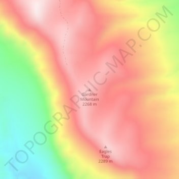
Name: Topografische Karte Gardner Mountain, Höhe, Relief.
Ort: Gardner Mountain, Johnson County, Wyoming, United States (43.79214 -106.89066 43.79224 -106.89056)
Durchschnittliche Höhe: 2’097 m
Minimale Höhe: 1’767 m
Maximale Höhe: 2’305 m
Andere topografische Karten
Klicken Sie auf eine Karte, um ihre Topografie, ihre Höhe und ihr Relief anzuzeigen.
Buffalo
United States > Wyoming > Johnson County
Buffalo, Johnson County, Wyoming, 82834, United States
Durchschnittliche Höhe: 1’437 m
Kaycee
United States > Wyoming > Johnson County
Kaycee, Johnson County, Wyoming, United States
Durchschnittliche Höhe: 1’431 m
Buffalo
United States > Wyoming > Johnson County
Buffalo, Johnson County, Wyoming, 82834, United States
Durchschnittliche Höhe: 1’442 m
Cloud Peak Glacier
United States > Wyoming > Johnson County
Cloud Peak Glacier, Johnson County, Wyoming, United States
Durchschnittliche Höhe: 3’603 m