
Spenden
Rüste dich für dein nächstes Abenteuer:
Als Amazon-Partner verdient diese Seite an qualifizierten Käufen, ohne dass Ihnen zusätzliche Kosten entstehen.
Topografische Karte Libby
Klicken Sie auf die Karte, um die Höhe anzuzeigen.
Spenden
Rüste dich für dein nächstes Abenteuer:
Als Amazon-Partner verdient diese Seite an qualifizierten Käufen, ohne dass Ihnen zusätzliche Kosten entstehen.
Libby
According to the United States Census Bureau, the city has an area of 1.95 square miles (5.05 km2), of which 1.91 square miles (4.95 km2) is land and 0.04 square miles (0.10 km2) is water. Libby is in the Kootenai National Forest, between the Cabinet Mountains to the south and the Purcell Mountains to the north, the town lies in the heart of the Kootenai Valley along the Kootenai River, and downstream from the Libby Dam. Libby is at an elevation of 2,096 feet (640 m) above sea level.
Spenden
Rüste dich für dein nächstes Abenteuer:
Als Amazon-Partner verdient diese Seite an qualifizierten Käufen, ohne dass Ihnen zusätzliche Kosten entstehen.
Über diese Karte
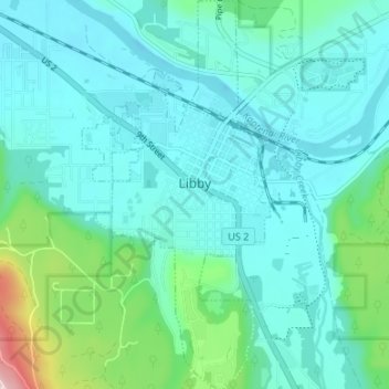
Name: Topografische Karte Libby, Höhe, Relief.
Ort: Libby, Lincoln County, Montana, United States (48.36478 -115.57527 48.40918 -115.54286)
Durchschnittliche Höhe: 676 m
Minimale Höhe: 617 m
Maximale Höhe: 970 m
Spenden
Rüste dich für dein nächstes Abenteuer:
Als Amazon-Partner verdient diese Seite an qualifizierten Käufen, ohne dass Ihnen zusätzliche Kosten entstehen.
Andere topografische Karten
Klicken Sie auf eine Karte, um ihre Topografie, ihre Höhe und ihr Relief anzuzeigen.
Kootenai River
United States > Montana > Lincoln County
Comparisons of various U.S. Geological Survey (USGS) topographic maps from the 20th century show many misinterpretations or alternative names being applied to the segment of the river within the United States. These include "Kootanie", "Kootenie", and "Kootienay". The Geographic Names Information System of the…
Durchschnittliche Höhe: 864 m
Spenden
Rüste dich für dein nächstes Abenteuer:
Als Amazon-Partner verdient diese Seite an qualifizierten Käufen, ohne dass Ihnen zusätzliche Kosten entstehen.
Spenden
Rüste dich für dein nächstes Abenteuer:
Als Amazon-Partner verdient diese Seite an qualifizierten Käufen, ohne dass Ihnen zusätzliche Kosten entstehen.