
Spenden
Rüste dich für dein nächstes Abenteuer:
Als Amazon-Partner verdient diese Seite an qualifizierten Käufen, ohne dass Ihnen zusätzliche Kosten entstehen.
Topografische Karte Wolf Creek
Klicken Sie auf die Karte, um die Höhe anzuzeigen.
Spenden
Rüste dich für dein nächstes Abenteuer:
Als Amazon-Partner verdient diese Seite an qualifizierten Käufen, ohne dass Ihnen zusätzliche Kosten entstehen.
Über diese Karte
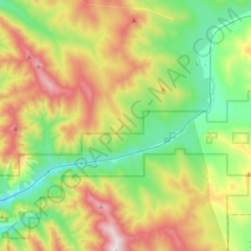
Name: Topografische Karte Wolf Creek, Höhe, Relief.
Ort: Wolf Creek, Lincoln County, Montana, United States (48.22922 -115.29363 48.34828 -115.03438)
Durchschnittliche Höhe: 1’225 m
Minimale Höhe: 796 m
Maximale Höhe: 1’988 m
Spenden
Rüste dich für dein nächstes Abenteuer:
Als Amazon-Partner verdient diese Seite an qualifizierten Käufen, ohne dass Ihnen zusätzliche Kosten entstehen.
Andere topografische Karten
Klicken Sie auf eine Karte, um ihre Topografie, ihre Höhe und ihr Relief anzuzeigen.
Libby
United States > Montana > Lincoln County
According to the United States Census Bureau, the city has an area of 1.95 square miles (5.05 km2), of which 1.91 square miles (4.95 km2) is land and 0.04 square miles (0.10 km2) is water. Libby is in the Kootenai National Forest, between the Cabinet Mountains to the south and the Purcell Mountains to the…
Durchschnittliche Höhe: 676 m
Troy
United States > Montana > Lincoln County
Troy is a city in Lincoln County, Montana, United States. The population was 797 at the 2020 census. It lies at the lowest elevation of any settlement in Montana. The town is on U.S. Route 2, near Montana Highway 56, in the Kootenai River gorge by the Kootenai National Forest.
Durchschnittliche Höhe: 729 m
Spenden
Rüste dich für dein nächstes Abenteuer:
Als Amazon-Partner verdient diese Seite an qualifizierten Käufen, ohne dass Ihnen zusätzliche Kosten entstehen.
Spenden
Rüste dich für dein nächstes Abenteuer:
Als Amazon-Partner verdient diese Seite an qualifizierten Käufen, ohne dass Ihnen zusätzliche Kosten entstehen.
Libby
United States > Montana > Lincoln County
According to the United States Census Bureau, the city has an area of 1.95 square miles (5.05 km2), of which 1.91 square miles (4.95 km2) is land and 0.04 square miles (0.10 km2) is water. Libby is in the Kootenai National Forest, between the Cabinet Mountains to the south and the Purcell Mountains to the…
Durchschnittliche Höhe: 676 m