
Topografische Karte Chatham
Interaktive Karte
Klicken Sie auf die Karte, um die Höhe anzuzeigen.
Über diese Karte
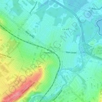
Name: Topografische Karte Chatham, Höhe, Relief.
Ort: Chatham, Morris County, New Jersey, United States (40.72430 -74.39975 40.75521 -74.36307)
Durchschnittliche Höhe: 76 m
Minimale Höhe: 51 m
Maximale Höhe: 141 m
The Passaic River, which rises at Millington Gorge in Long Hill Township and defines the Great Swamp, flows north along the eastern boundary of Chatham. A good crossing location, identified by Native Americans to early European settlers, figured significantly in the colonial history of the community. Fairmount Avenue ascends Long Hill perpendicularly from Main Street in the contemporary center of town to the highest elevation of the town among the Watchung Mountains. From there, one may see the lights of New York beyond the crest of the ridge hills of Summit and Short Hills. Water from artesian wells is stored at its crest to provide the drinking water for the community.
Andere topografische Karten
Klicken Sie auf eine Karte, um ihre Topografie, ihre Höhe und ihr Relief anzuzeigen.
Randolph Township
United States > New Jersey > Morris County
Randolph Township, Morris County, New Jersey, 07869, United States
Durchschnittliche Höhe: 247 m
Mount Olive
United States > New Jersey > Morris County
Mount Olive, Morris County, New Jersey, United States
Durchschnittliche Höhe: 280 m
Montville Township
United States > New Jersey > Morris County > Montville Township
Montville Township, Morris County, New Jersey, United States
Durchschnittliche Höhe: 115 m
Parsippany-Troy Hills
United States > New Jersey > Morris County
Parsippany-Troy Hills, Morris County, New Jersey, United States
Durchschnittliche Höhe: 113 m
Rockaway
United States > New Jersey > Morris County
Rockaway, Morris County, New Jersey, United States
Durchschnittliche Höhe: 196 m