
Topografische Karte Tinian
Interaktive Karte
Klicken Sie auf die Karte, um die Höhe anzuzeigen.
Über diese Karte
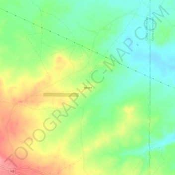
Name: Topografische Karte Tinian, Höhe, Relief.
Durchschnittliche Höhe: 2’014 m
Minimale Höhe: 1’975 m
Maximale Höhe: 2’069 m
Andere topografische Karten
Klicken Sie auf eine Karte, um ihre Topografie, ihre Höhe und ihr Relief anzuzeigen.
Tekapo
United States > New Mexico > McKinley County
Tekapo, McKinley County, New Mexico, United States
Durchschnittliche Höhe: 1’900 m
Umbrella Rock
United States > New Mexico > McKinley County
Umbrella Rock, Eastern Navajo Agency, McKinley County, New Mexico, United States
Durchschnittliche Höhe: 2’168 m
Smith Lake
United States > New Mexico > McKinley County
Smith Lake, Eastern Navajo Agency, McKinley County, New Mexico, United States
Durchschnittliche Höhe: 2’221 m
Mesa Redondita
United States > New Mexico > McKinley County
Mesa Redondita, McKinley County, New Mexico, United States
Durchschnittliche Höhe: 2’225 m
China Springs
United States > New Mexico > McKinley County
China Springs, McKinley County, New Mexico, 87317, United States
Durchschnittliche Höhe: 2’065 m
Crownpoint
United States > New Mexico > McKinley County > Crownpoint
Crownpoint, Eastern Navajo Agency, McKinley County, New Mexico, 87313, United States
Durchschnittliche Höhe: 2’099 m
Zuni Pueblo
United States > New Mexico > McKinley County > Zuni
Zuni Pueblo, Zuni, McKinley County, New Mexico, 87327, United States
Durchschnittliche Höhe: 1’944 m
Fort Wingate
United States > New Mexico > McKinley County > Fort Wingate
Fort Wingate, McKinley County, New Mexico, 87316, United States
Durchschnittliche Höhe: 2’156 m