
Topografische Karte La Urz
Interaktive Karte
Klicken Sie auf die Karte, um die Höhe anzuzeigen.
Über diese Karte
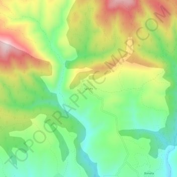
Name: Topografische Karte La Urz, Höhe, Relief.
Ort: La Urz, Riello, León, Castilla y León, 24127, España (42.79714 -5.97257 42.83714 -5.93257)
Durchschnittliche Höhe: 1’236 m
Minimale Höhe: 1’074 m
Maximale Höhe: 1’466 m
Está situada a media ladera, a una altitud de 1220 m por encima del valle del arroyo Curueña. Las poblaciones más cercanas son Bonella y Socil al sur, Curueña al norte, y Villarín de Riello y Robledo de Omaña al oeste.
Andere topografische Karten
Klicken Sie auf eine Karte, um ihre Topografie, ihre Höhe und ihr Relief anzuzeigen.
Peña del Palomar
España > Castilla y León > Riello
Peña del Palomar, Riello, León, Castilla y León, España
Durchschnittliche Höhe: 1’569 m
Villarubia
España > Castilla y León > Riello > Manzaneda de Omaña
Villarubia, Manzaneda de Omaña, Riello, León, Castilla y León, España
Durchschnittliche Höhe: 1’256 m
Piedra Hincada
España > Castilla y León > Riello
Piedra Hincada, Riello, León, Castilla y León, España
Durchschnittliche Höhe: 1’564 m