
Topografische Karte Peña del Palomar
Interaktive Karte
Klicken Sie auf die Karte, um die Höhe anzuzeigen.
Über diese Karte
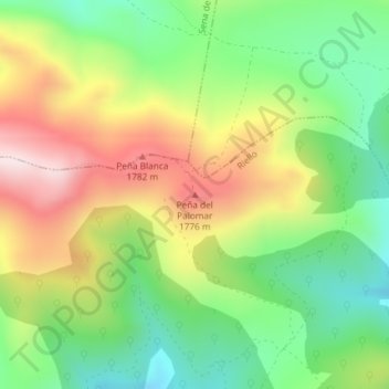
Name: Topografische Karte Peña del Palomar, Höhe, Relief.
Ort: Peña del Palomar, Riello, León, Castilla y León, España (42.86429 -5.95012 42.86439 -5.95002)
Durchschnittliche Höhe: 1’569 m
Minimale Höhe: 1’356 m
Maximale Höhe: 1’854 m
Andere topografische Karten
Klicken Sie auf eine Karte, um ihre Topografie, ihre Höhe und ihr Relief anzuzeigen.
La Urz
España > Castilla y León > Riello
La Urz, Riello, León, Castilla y León, 24127, España
Durchschnittliche Höhe: 1’236 m
Villarubia
España > Castilla y León > Riello > Manzaneda de Omaña
Villarubia, Manzaneda de Omaña, Riello, León, Castilla y León, España
Durchschnittliche Höhe: 1’256 m
Piedra Hincada
España > Castilla y León > Riello
Piedra Hincada, Riello, León, Castilla y León, España
Durchschnittliche Höhe: 1’564 m