
Topografische Karte West Hartford
Interaktive Karte
Klicken Sie auf die Karte, um die Höhe anzuzeigen.
Über diese Karte
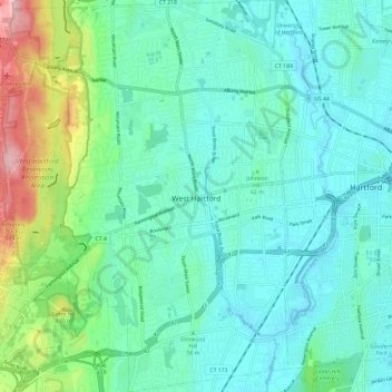
Name: Topografische Karte West Hartford, Höhe, Relief.
Durchschnittliche Höhe: 60 m
Minimale Höhe: 9 m
Maximale Höhe: 250 m
The west side of West Hartford is flanked by the Metacomet Ridge, a mountainous trap rock ridgeline that stretches from Long Island Sound to nearly the Vermont border. Notable features of the Metacomet Ridge in West Hartford include Talcott Mountain and a number of highland water reservoirs belonging to the Metropolitan District, which maintains watershed and recreation resources on the property. The 51-mile-long (82 km) Metacomet Trail traverses the ridge. The town's web site indicates that the highest point in town is 778 feet (237 m) above sea level on Talcott (Avon) Mountain. The altitude at Town Hall is 120 feet (37 m).
Andere topografische Karten
Klicken Sie auf eine Karte, um ihre Topografie, ihre Höhe und ihr Relief anzuzeigen.
Whites Hill
United States > Connecticut > Capitol Planning Region > Bolton
Whites Hill, Bolton, Capitol Planning Region, Connecticut, 06043, United States
Durchschnittliche Höhe: 205 m
Glastonbury
United States > Connecticut > Capitol Planning Region
Glastonbury, Capitol Planning Region, Connecticut, United States
Durchschnittliche Höhe: 67 m
South Windsor
United States > Connecticut > Capitol Planning Region
South Windsor, Capitol Planning Region, Connecticut, United States
Durchschnittliche Höhe: 42 m
Hartford County
United States > Connecticut > Capitol Planning Region
Hartford County, Capitol Planning Region, Connecticut, United States
Durchschnittliche Höhe: 122 m
Hartford
United States > Connecticut > Capitol Planning Region
Hartford, Capitol Planning Region, Connecticut, United States
Durchschnittliche Höhe: 23 m