
Topografische Karte Glastonbury
Interaktive Karte
Klicken Sie auf die Karte, um die Höhe anzuzeigen.
Über diese Karte
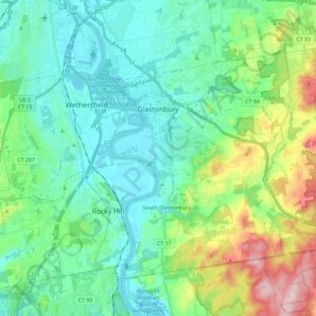
Name: Topografische Karte Glastonbury, Höhe, Relief.
Durchschnittliche Höhe: 67 m
Minimale Höhe: 0 m
Maximale Höhe: 273 m
The town center experiences a humid continental climate (Dfa). However, the rural parts of the town, at an elevation of 800 feet near Bolton and Hebron, experience a colder climate which straddles the (Dfa) and (Dfb) lines.
Andere topografische Karten
Klicken Sie auf eine Karte, um ihre Topografie, ihre Höhe und ihr Relief anzuzeigen.
West Hartford
United States > Connecticut > Capitol Planning Region
West Hartford, Capitol Planning Region, Connecticut, United States
Durchschnittliche Höhe: 60 m
Whites Hill
United States > Connecticut > Capitol Planning Region > Bolton
Whites Hill, Bolton, Capitol Planning Region, Connecticut, 06043, United States
Durchschnittliche Höhe: 205 m
South Windsor
United States > Connecticut > Capitol Planning Region
South Windsor, Capitol Planning Region, Connecticut, United States
Durchschnittliche Höhe: 42 m
Hartford County
United States > Connecticut > Capitol Planning Region
Hartford County, Capitol Planning Region, Connecticut, United States
Durchschnittliche Höhe: 122 m
Hartford
United States > Connecticut > Capitol Planning Region
Hartford, Capitol Planning Region, Connecticut, United States
Durchschnittliche Höhe: 23 m