
Topografische Karte Caltanissetta
Interaktive Karte
Klicken Sie auf die Karte, um die Höhe anzuzeigen.
Über diese Karte
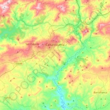
Name: Topografische Karte Caltanissetta, Höhe, Relief.
Ort: Caltanissetta, Sicily, 93100, Italy (37.32933 13.86167 37.59813 14.15923)
Durchschnittliche Höhe: 428 m
Minimale Höhe: 158 m
Maximale Höhe: 849 m
In 2017, the city had a population of 62,797.[4] It is the 14th largest comune in Italy measured by area, the sixth highest comune in Italy by elevation (568 m), the second highest elevation in Sicily after the city of Enna (912 m).
Andere topografische Karten
Klicken Sie auf eine Karte, um ihre Topografie, ihre Höhe und ihr Relief anzuzeigen.
Bompensiere
Italy > Sicily > Caltanissetta
Bompensiere, Caltanissetta, Sicily, 93010, Italy
Durchschnittliche Höhe: 319 m
Mussomeli
Italy > Sicily > Caltanissetta
Mussomeli, Caltanissetta, Sicily, 93014, Italy
Durchschnittliche Höhe: 420 m