
Spenden
Rüste dich für dein nächstes Abenteuer:
Als Amazon-Partner verdient diese Seite an qualifizierten Käufen, ohne dass Ihnen zusätzliche Kosten entstehen.
Topografische Karte Gunpowder Park
Klicken Sie auf die Karte, um die Höhe anzuzeigen.
Spenden
Rüste dich für dein nächstes Abenteuer:
Als Amazon-Partner verdient diese Seite an qualifizierten Käufen, ohne dass Ihnen zusätzliche Kosten entstehen.
Über diese Karte
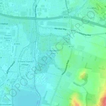
Name: Topografische Karte Gunpowder Park, Höhe, Relief.
Durchschnittliche Höhe: 24 m
Minimale Höhe: 11 m
Maximale Höhe: 81 m
Spenden
Rüste dich für dein nächstes Abenteuer:
Als Amazon-Partner verdient diese Seite an qualifizierten Käufen, ohne dass Ihnen zusätzliche Kosten entstehen.
Andere topografische Karten
Klicken Sie auf eine Karte, um ihre Topografie, ihre Höhe und ihr Relief anzuzeigen.
Connaught Water
United Kingdom > England > Essex > Epping Forest > Sewardstonebury
Durchschnittliche Höhe: 57 m
Spenden
Rüste dich für dein nächstes Abenteuer:
Als Amazon-Partner verdient diese Seite an qualifizierten Käufen, ohne dass Ihnen zusätzliche Kosten entstehen.
Nazeing Gate
United Kingdom > England > Essex > Epping Forest > Bumble's Green > Nazeing
Durchschnittliche Höhe: 70 m
Spenden
Rüste dich für dein nächstes Abenteuer:
Als Amazon-Partner verdient diese Seite an qualifizierten Käufen, ohne dass Ihnen zusätzliche Kosten entstehen.
Epping Forest
United Kingdom > England > Essex > Epping Forest > Debden Green
It lies on a ridge between the valleys of the rivers Lea and Roding. It contains areas of woodland, grassland, heath, streams, bogs and ponds, and its elevation and thin gravelly soil (the result of glaciation) historically made it less suitable for agriculture. The Forest was historically managed as a common;…
Durchschnittliche Höhe: 44 m
Spenden
Rüste dich für dein nächstes Abenteuer:
Als Amazon-Partner verdient diese Seite an qualifizierten Käufen, ohne dass Ihnen zusätzliche Kosten entstehen.
Stanford Rivers
United Kingdom > England > Essex > Epping Forest > Stanford Rivers
Durchschnittliche Höhe: 65 m
Spenden
Rüste dich für dein nächstes Abenteuer:
Als Amazon-Partner verdient diese Seite an qualifizierten Käufen, ohne dass Ihnen zusätzliche Kosten entstehen.
Epping Forest
United Kingdom > England > Essex > Epping Forest > Debden Green
Durchschnittliche Höhe: 77 m
Passingford Bridge
United Kingdom > England > Essex > Epping Forest > Stapleford Tawney
Durchschnittliche Höhe: 53 m
Spenden
Rüste dich für dein nächstes Abenteuer:
Als Amazon-Partner verdient diese Seite an qualifizierten Käufen, ohne dass Ihnen zusätzliche Kosten entstehen.
Hangman's Hill
United Kingdom > England > Essex > Epping Forest > Loughton
Durchschnittliche Höhe: 64 m
Thornwood Common
United Kingdom > England > Essex > Epping Forest > Thornwood Common
Durchschnittliche Höhe: 89 m
Spenden
Rüste dich für dein nächstes Abenteuer:
Als Amazon-Partner verdient diese Seite an qualifizierten Käufen, ohne dass Ihnen zusätzliche Kosten entstehen.
Spenden
Rüste dich für dein nächstes Abenteuer:
Als Amazon-Partner verdient diese Seite an qualifizierten Käufen, ohne dass Ihnen zusätzliche Kosten entstehen.
Steward's Green
United Kingdom > England > Essex > Epping Forest > Coopersale Street > Steward's Green
Durchschnittliche Höhe: 76 m
Shelley
United Kingdom > England > Essex > Epping Forest > Chipping Ongar
Durchschnittliche Höhe: 58 m
Spenden
Rüste dich für dein nächstes Abenteuer:
Als Amazon-Partner verdient diese Seite an qualifizierten Käufen, ohne dass Ihnen zusätzliche Kosten entstehen.
How Green
United Kingdom > England > Essex > Epping Forest > Stapleford Abbotts
Durchschnittliche Höhe: 63 m
Epping Forest
United Kingdom > England > Essex > Epping Forest > Debden Green
It lies on a ridge between the valleys of the rivers Lea and Roding. It contains areas of woodland, grassland, heath, streams, bogs, and ponds, and its elevation and thin gravelly soil (the result of glaciation) historically made it less suitable for agriculture. The forest was historically managed as a…
Durchschnittliche Höhe: 44 m
Epping Forest
United Kingdom > England > Essex > Epping Forest
It lies on a ridge between the valleys of the rivers Lea and Roding. It contains areas of woodland, grassland, heath, streams, bogs, and ponds, and its elevation and thin gravelly soil (the result of glaciation) historically made it less suitable for agriculture. The forest was historically managed as a…
Durchschnittliche Höhe: 44 m
Spenden
Rüste dich für dein nächstes Abenteuer:
Als Amazon-Partner verdient diese Seite an qualifizierten Käufen, ohne dass Ihnen zusätzliche Kosten entstehen.
Passingford Bridge
United Kingdom > England > Essex > Epping Forest > Stapleford Tawney
Durchschnittliche Höhe: 53 m