
Topografische Karte Berners Roding
Klicken Sie auf die Karte, um die Höhe anzuzeigen.
Über diese Karte
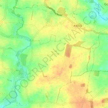
Name: Topografische Karte Berners Roding, Höhe, Relief.
Durchschnittliche Höhe: 65 m
Minimale Höhe: 47 m
Maximale Höhe: 78 m
Andere topografische Karten
Klicken Sie auf eine Karte, um ihre Topografie, ihre Höhe und ihr Relief anzuzeigen.
Connaught Water
United Kingdom > England > Essex > Epping Forest > Sewardstonebury
Durchschnittliche Höhe: 57 m
Dobbs Weir Lock
United Kingdom > England > Essex > Epping Forest > Nazeing
Durchschnittliche Höhe: 31 m
Roughtalley's Wood (South) & Epping Forest Woodland Burial Ground
United Kingdom > England > Essex > Epping Forest > Coopersale
Durchschnittliche Höhe: 96 m
Epping Forest
United Kingdom > England > Essex > Epping Forest > Debden Green
It lies on a ridge between the valleys of the rivers Lea and Roding. It contains areas of woodland, grassland, heath, streams, bogs and ponds, and its elevation and thin gravelly soil (the result of glaciation) historically made it less suitable for agriculture. The Forest was historically managed as a common;…
Durchschnittliche Höhe: 44 m
Stanford Rivers
United Kingdom > England > Essex > Epping Forest > Stanford Rivers
Durchschnittliche Höhe: 65 m
Epping Forest
United Kingdom > England > Essex > Epping Forest > Debden Green
Durchschnittliche Höhe: 77 m
Epping Forest
United Kingdom > England > Essex > Epping Forest > Debden Green
It lies on a ridge between the valleys of the rivers Lea and Roding. It contains areas of woodland, grassland, heath, streams, bogs, and ponds, and its elevation and thin gravelly soil (the result of glaciation) historically made it less suitable for agriculture. The forest was historically managed as a…
Durchschnittliche Höhe: 44 m
Epping Forest
United Kingdom > England > Essex > Epping Forest
It lies on a ridge between the valleys of the rivers Lea and Roding. It contains areas of woodland, grassland, heath, streams, bogs, and ponds, and its elevation and thin gravelly soil (the result of glaciation) historically made it less suitable for agriculture. The forest was historically managed as a…
Durchschnittliche Höhe: 44 m