
Topografische Karte Le Pouget
Interaktive Karte
Klicken Sie auf die Karte, um die Höhe anzuzeigen.
Über diese Karte
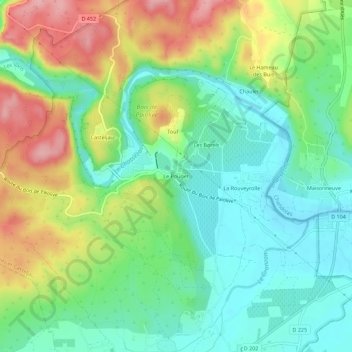
Name: Topografische Karte Le Pouget, Höhe, Relief.
Durchschnittliche Höhe: 162 m
Minimale Höhe: 108 m
Maximale Höhe: 254 m
Andere topografische Karten
Klicken Sie auf eine Karte, um ihre Topografie, ihre Höhe und ihr Relief anzuzeigen.
Mazet
France > Auvergne-Rhône-Alpes > Ardèche > Berrias-et-Casteljau
Mazet, Casteljau, Berrias-et-Casteljau, Largentière, Ardèche, Auvergne-Rhône-Alpes, France métropolitaine, 07460, France
Durchschnittliche Höhe: 171 m
Le Hameau des Buis
France > Auvergne-Rhône-Alpes > Ardèche > Berrias-et-Casteljau
Le Hameau des Buis, Casteljau, Berrias-et-Casteljau, Largentière, Ardèche, Auvergne-Rhône-Alpes, France métropolitaine, 07460, France
Durchschnittliche Höhe: 170 m
Grotte de la Tardive
France > Auvergne-Rhône-Alpes > Ardèche > Berrias-et-Casteljau > Casteljau
Grotte de la Tardive, La Presqu'Île, Casteljau, Berrias-et-Casteljau, Largentière, Ardèche, Auvergne-Rhône-Alpes, France métropolitaine, 07460, France
Durchschnittliche Höhe: 178 m
Les Borels
France > Auvergne-Rhône-Alpes > Ardèche > Berrias-et-Casteljau
Les Borels, Casteljau, Berrias-et-Casteljau, Largentière, Ardèche, Auvergne-Rhône-Alpes, France métropolitaine, 07460, France
Durchschnittliche Höhe: 164 m
Casteljau
France > Auvergne-Rhône-Alpes > Ardèche > Berrias-et-Casteljau
Casteljau, Berrias-et-Casteljau, Largentière, Ardèche, Auvergne-Rhône-Alpes, France métropolitaine, 07460, France
Durchschnittliche Höhe: 180 m
Berrias
France > Auvergne-Rhône-Alpes > Ardèche > Berrias-et-Casteljau
Berrias, Berrias-et-Casteljau, Largentière, Ardèche, Auvergne-Rhône-Alpes, France métropolitaine, 07460, France
Durchschnittliche Höhe: 174 m