Geolokalisieren

Topografische Karte Outwoods

Klicken Sie auf die Karte, um die Höhe anzuzeigen.

Über diese Karte

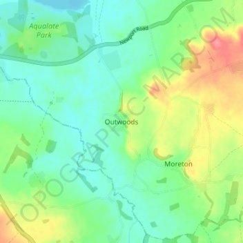
Name: Topografische Karte Outwoods, Höhe, Relief.

Ort: Outwoods, Stafford, Staffordshire, England, TF10 9EA, United Kingdom (52.73933 -2.33898 52.77933 -2.29898)

Durchschnittliche Höhe: 88 m

Minimale Höhe: 63 m

Maximale Höhe: 138 m

Andere topografische Karten

Klicken Sie auf eine Karte, um ihre Topografie, ihre Höhe und ihr Relief anzuzeigen.

Colwich

United Kingdom > England > Staffordshire > Stafford

Durchschnittliche Höhe: 104 m

Fulford

United Kingdom > England > Staffordshire > Stafford

Durchschnittliche Höhe: 200 m

Chebsey

United Kingdom > England > Staffordshire > Stafford

Durchschnittliche Höhe: 101 m

Church Eaton

United Kingdom > England > Staffordshire > Stafford

Durchschnittliche Höhe: 104 m

Tixall

United Kingdom > England > Staffordshire > Stafford

Durchschnittliche Höhe: 92 m

Barlaston

United Kingdom > England > Staffordshire > Stafford

Durchschnittliche Höhe: 132 m

Stowe-by-Chartley

United Kingdom > England > Staffordshire > Stafford

Durchschnittliche Höhe: 124 m

Aqualate Mere

United Kingdom > England > Staffordshire > Stafford > Forton

Durchschnittliche Höhe: 74 m

Adbaston

United Kingdom > England > Staffordshire > Stafford

Durchschnittliche Höhe: 110 m

Marston

United Kingdom > England > Staffordshire > Stafford > Marston

Durchschnittliche Höhe: 105 m

Swynnerton

United Kingdom > England > Staffordshire > Stafford

Durchschnittliche Höhe: 133 m

Ranton

United Kingdom > England > Staffordshire > Stafford

Durchschnittliche Höhe: 103 m

Swynnerton

United Kingdom > England > Staffordshire > Stafford

Durchschnittliche Höhe: 133 m

Ingestre

United Kingdom > England > Staffordshire > Stafford

Durchschnittliche Höhe: 92 m

Fradswell

United Kingdom > England > Staffordshire > Stafford > Fradswell

Durchschnittliche Höhe: 143 m

Hilderstone

United Kingdom > England > Staffordshire > Stafford

Durchschnittliche Höhe: 188 m

Brocton

United Kingdom > England > Staffordshire > Stafford

Durchschnittliche Höhe: 142 m

Weston

United Kingdom > England > Staffordshire > Stafford

Durchschnittliche Höhe: 93 m

Gnosall

United Kingdom > England > Staffordshire > Stafford

Durchschnittliche Höhe: 105 m

Hixon

United Kingdom > England > Staffordshire > Stafford

Durchschnittliche Höhe: 93 m

Rüste dich für dein nächstes Abenteuer:

🧤Winter‑Outdoor‑Handschuhe - Warme Handschuhe für kalte Touren
🛰️GPS-Handgeräte - Präzise Navigation für anspruchsvolle Bergrouten in den Alpen
🧭Analoge Höhenmesser - Zuverlässig ohne Batterien die Höhe bestimmen
📢Signalpfeifen - Gesehen und gehört werden in Notsituationen
🎒Kindertragen / Kraxen - Die ganze Familie auf topografischen Entdeckungsreisen

Als Amazon-Partner verdient diese Seite an qualifizierten Käufen, ohne dass Ihnen zusätzliche Kosten entstehen.