Geolokalisieren

Topografische Karte Hilderstone

Klicken Sie auf die Karte, um die Höhe anzuzeigen.

Über diese Karte

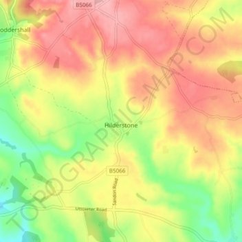
Name: Topografische Karte Hilderstone, Höhe, Relief.

Ort: Hilderstone, Stafford, Staffordshire, England, United Kingdom (52.89538 -2.10813 52.92900 -2.03297)

Durchschnittliche Höhe: 188 m

Minimale Höhe: 118 m

Maximale Höhe: 244 m

Andere topografische Karten

Klicken Sie auf eine Karte, um ihre Topografie, ihre Höhe und ihr Relief anzuzeigen.

Aston-by-Stone

United Kingdom > England > Staffordshire > Stafford

Durchschnittliche Höhe: 108 m

Beffcote

United Kingdom > England > Staffordshire > Stafford > Gnosall

Durchschnittliche Höhe: 99 m

Great Haywood

United Kingdom > England > Staffordshire > Stafford

Durchschnittliche Höhe: 90 m

Hooks Green

United Kingdom > England > Staffordshire > Stafford

Durchschnittliche Höhe: 154 m

Woodseaves

United Kingdom > England > Staffordshire > Stafford

Durchschnittliche Höhe: 122 m

Marston

United Kingdom > England > Staffordshire > Stafford

Durchschnittliche Höhe: 105 m

Standon Mill

United Kingdom > England > Staffordshire > Stafford

Durchschnittliche Höhe: 119 m

Outwoods

United Kingdom > England > Staffordshire > Stafford

Durchschnittliche Höhe: 88 m

Moreton

United Kingdom > England > Staffordshire > Stafford

Durchschnittliche Höhe: 95 m

Bradley

United Kingdom > England > Staffordshire > Stafford

Durchschnittliche Höhe: 110 m

Hopton

United Kingdom > England > Staffordshire > Stafford

Durchschnittliche Höhe: 106 m

Aqualate Mere

United Kingdom > England > Staffordshire > Stafford > Forton

Durchschnittliche Höhe: 74 m

Vielen Dank für die Unterstützung dieser Website ❤️
Spenden

St James Green

United Kingdom > England > Staffordshire > Stafford

Durchschnittliche Höhe: 124 m

Meir Heath

United Kingdom > England > Staffordshire > Stafford

Durchschnittliche Höhe: 200 m

Little Haywood

United Kingdom > England > Staffordshire > Stafford

Durchschnittliche Höhe: 100 m

Moddershall

United Kingdom > England > Staffordshire > Stafford

Durchschnittliche Höhe: 185 m

Milford

United Kingdom > England > Staffordshire > Stafford > Milford

Durchschnittliche Höhe: 103 m

Knightley

United Kingdom > England > Staffordshire > Stafford > Gnosall > Knightley

Durchschnittliche Höhe: 127 m

Yarnfield

United Kingdom > England > Staffordshire > Stafford

Durchschnittliche Höhe: 108 m

Beech

United Kingdom > England > Staffordshire > Stafford > Beech

Durchschnittliche Höhe: 153 m

Drointon

United Kingdom > England > Staffordshire > Stafford > Stowe-by-Chartley

Durchschnittliche Höhe: 110 m

Rüste dich für dein nächstes Abenteuer:

🥾Wanderschuhe Damen - Komfortable Wanderschuhe mit gutem Grip für lange Wanderungen
🧼Schuhpflege‑Sets - Pflege für langlebige Wander‑ und Outdoor‑Schuhe
🧦Wandersocken aus Merino - Blasenfrei wandern dank hochwertiger Merinowolle
🩹Blasenpflaster & Fußpflege - Erste Hilfe für Füße bei langen Touren
🏕️Familien‑Campingausrüstung - Ausrüstung für Camping mit Familie

Als Amazon-Partner verdient diese Seite an qualifizierten Käufen, ohne dass Ihnen zusätzliche Kosten entstehen.