
Topografische Karte Grand Canyon
Interaktive Karte
Klicken Sie auf die Karte, um die Höhe anzuzeigen.
Über diese Karte
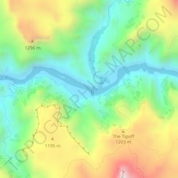
Name: Topografische Karte Grand Canyon, Höhe, Relief.
Ort: Grand Canyon, Coconino County, Arizona, United States (36.09769 -112.09681 36.09779 -112.09671)
Durchschnittliche Höhe: 1’021 m
Minimale Höhe: 738 m
Maximale Höhe: 1’519 m
Uplift associated with mountain formation later moved these sediments thousands of feet upward and created the Colorado Plateau. The higher elevation has also resulted in greater precipitation in the Colorado River drainage area, but not enough to change the Grand Canyon area from being semi-arid. The uplift of the Colorado Plateau is uneven, and the Kaibab Plateau that the Grand Canyon bisects is over one thousand feet (300 m) higher at the North Rim than at the South Rim. Almost all runoff from the North Rim (which also gets more rain and snow) flows toward the Grand Canyon, while much of the runoff on the plateau behind the South Rim flows away from the canyon (following the general tilt). The result is deeper and longer tributary washes and canyons on the north side and shorter and steeper side canyons on the south side.
Andere topografische Karten
Klicken Sie auf eine Karte, um ihre Topografie, ihre Höhe und ihr Relief anzuzeigen.
Williams
United States > Arizona > Coconino County
Williams, Coconino County, Arizona, 86046, United States
Durchschnittliche Höhe: 2’131 m
Grand Canyon Village
United States > Arizona > Coconino County
Grand Canyon Village, Coconino County, Arizona, United States
Durchschnittliche Höhe: 1’778 m
Sunset Crater
United States > Arizona > Coconino County
Sunset Crater, Coconino County, Arizona, United States
Durchschnittliche Höhe: 2’168 m
Antelope Canyon
United States > Arizona > Coconino County
Antelope Canyon, Coconino County, Arizona, United States
Durchschnittliche Höhe: 1’202 m
One Mile
United States > Arizona > Coconino County
One Mile, Coconino County, Arizona, United States
Durchschnittliche Höhe: 1’817 m
Flagstaff
United States > Arizona > Coconino County > Flagstaff
Flagstaff, Coconino County, Arizona, United States
Durchschnittliche Höhe: 2’151 m
The Gap
United States > Arizona > Coconino County > The Gap
The Gap, Coconino County, Arizona, United States
Durchschnittliche Höhe: 1’673 m
Jack Stephens Tank
United States > Arizona > Coconino County
Jack Stephens Tank, Coconino County, Arizona, United States
Durchschnittliche Höhe: 1’851 m