
Topografische Karte Pie Town
Interaktive Karte
Klicken Sie auf die Karte, um die Höhe anzuzeigen.
Über diese Karte
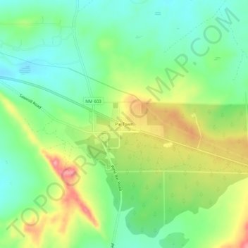
Name: Topografische Karte Pie Town, Höhe, Relief.
Ort: Pie Town, Catron County, New Mexico, 87827, United States (34.27964 -108.15254 34.31964 -108.11254)
Durchschnittliche Höhe: 2’352 m
Minimale Höhe: 2’306 m
Maximale Höhe: 2’425 m
Andere topografische Karten
Klicken Sie auf eine Karte, um ihre Topografie, ihre Höhe und ihr Relief anzuzeigen.
Quemado
United States > New Mexico > Catron County
Quemado, Catron County, New Mexico, 87829, United States
Durchschnittliche Höhe: 2’113 m
San Francisco
United States > New Mexico > Catron County
San Francisco, Catron County, New Mexico, United States
Durchschnittliche Höhe: 2’440 m
Glenwood
United States > New Mexico > Catron County
Glenwood, Catron County, New Mexico, 88039, United States
Durchschnittliche Höhe: 1’526 m
Zuni Salt Lake
United States > New Mexico > Catron County > Salt Lake
Zuni Salt Lake, Salt Lake, Catron County, New Mexico, United States
Durchschnittliche Höhe: 1’940 m